![[NOAA]](../img/noaa.gif) ![[ETL]](../img/etl.gif) |
|
|
Daily Nauru99 Report NOAA Ship RONALD H. BROWN Previous <- 6/27/99 -> Next
Time:27 June, 1999 (Julian Day 178) Visual Observations:Today is a duplicate of yesterday (fair with scattered MBL cumuli), perhaps with slightly more cloud coverage. Notable Events and Anecdotes:Ship's crew continues to scrape and paint - a perpetual job on ships. Cessna returned today twice, and on its second trip it sawtooth-profiled in the vicinity of RHB up to 2 km altitude, then down again before returning to Nauru. Sea turtles have been spotted by a few sharp-eyed observers; dolphin sightings proliferate. We remain stationary 100-200 m from the TAO buoy, turning somewhat at sunset to keep radiometers from being shaded by the ship's superstructure. Instrument Status: DABUL lidar is down for the count. It lost its laser and no spare is on hand because of the manufacturer's lethargy and inability to repair previously-failed units. It will be packed immediately for shipment back to Boulder. |
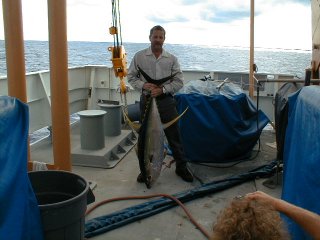
Ship's engineer Brian Mitchell displays his just-caught 57-pound yellow fin tuna on the fantail of RHB. This bodes well for the next few lunches and dinners for all hands. Fishing is permitted when it does not interfer with scientific observations. |
| NOAA |
ETL |
Nauru 99 |
Webmaster Updated: June 1999 |
|