![[NOAA]](../img/noaa.gif) ![[ETL]](../img/etl.gif) |
|
|
Daily Nauru99 Report NOAA Ship RONALD H. BROWN Previous <- 06/26/99 -> Next
Time:1515 Local, 0315 Z
Visual Observations:Another day with consistent wind and many puffy MBL cumuli clouds, 3-5 m swells, and occasional whitecaps. In the morning there was considerable convection and rain in the region but these dissipated quickly with no appreciable "action" since. Notable Events and Anecdotes:People are settling into a comfortable routine now, with only occasional attempts to improve instrument performance. Fishing was a total bust yesterday, but two curious dolphins played near our small fishing craft to lift spirits. The Cessna took today off (2 days on, one day off). Scientists are preparing overheads for tonight's talk, part of a continuing Tuesday - Saturday "seminar" series for all hands. We continue to hold station within 200 m of the TAO buoy. Instrument Status:Problems with the Licor CO2 bow tower system were solved - we fixed an inoperative pump. The combined products satellite workstation is functioning well again after software surgery. Interesting convolutions in the MBL layer have been observed by the lidars. |
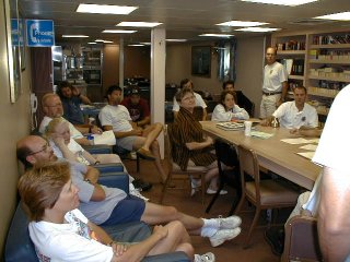
Scientists meet daily after breakfast in the library to go over plans, weather forecasts, satellite overflights, and request ship support. In the background is messdecks (dining room to land lubbers). |
| NOAA |
ETL |
Nauru 99 |
Webmaster Updated: June 1999 |
|