![[NOAA]](../img/noaa.gif) ![[ETL]](../img/etl.gif) |
|
|
Daily Nauru99 Report NOAA Ship RONALD H. BROWN Previous <- 06/17/99 -> Next
Time: 1520 Local, 0520 Z Notable Events and Anecdotes: Several scientists are groggy today (sea sick). RHB lost a "drag race" with a freighter. Several flying fish were spotted. At night the DABUL lidar beam appears as green light column rising into the empty sky. Tonight we embark a pilot to guide RHB through Torres Straits (required by regulation). We are building an intranet system to post and share data and images. A series of informal seminars by Nauru99 investigators begins in two days and will occuring twice per week; the talks will be for both the ship's crew and the science party. Instrument Status: All doing well, but not all are taking data due to salt spray. |
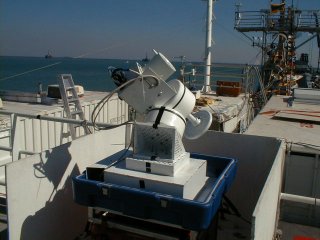
Pennsylvania State University's 7-channel stabilized sun photometer on 03 deck. Three times daily 3 other hand-held sun photometers are also used to take corroborating data. |
| NOAA |
ETL |
Nauru 99 |
Webmaster Updated: 17 June 1999 |
|