Boulder wind info
Boulder has some of the highest peak winds of any city in the US. Below is a list of significant Boulder area wind events and a table of high wind events per month. Inconsistent reporting may mean that events are missing or that the wind speeds are not accurate.
For more recent events and for more detailed info, see: Severe Weather Database in the US from NCEI. NCEI maintains a link to PDF versions of the severe weather bulletin going furthe back in time.
Fires and Winds
There have been fires associated with strong winds in the Boulder area. See Apr 6-7 1969, Jan 18 2006, Jan 7 2009, Feb 9-10 2017, and Dec 30 2021. The 2006, 2017, and 2021 were grass fires.
Other links of interest
- National Renewable Energy Laboratory (NREL)
- Seasonal cycle of Boulder winds
- What causes wave clouds
All speeds in MPH unless indicated. Gust is peak gust in Boulder (or very near) unless indicated. Dates with gusts greater or equal to 100 MPH are shaded darker pink. Those 80 and over are lighter pink.
1966
| Year | Date(s) | Time of day | Gusts | Comments |
|---|
| 1966 | Sep 13-14 | unknown | 60+ | snow,extensive tree damage |
1967
| Year | Date(s) | Time of day | Gusts | Comments |
|---|
| 1967 | Jan 15-16 | night | 125 | NCAR (75 city) Chinook |
| 1967 | Dec 6-7 | 8am-noon | ~75 | |
1968
| Year | Date(s) | Time of day | Gusts | Comments |
|---|
| 1968 | Dec 4 | midday | >50 | |
| 1968 | Dec 11-12 | 10pm-11am | 50-75 | |
1969
| Year | Date(s) | Time of day | Gusts | Comments |
|---|
| 1969 | Jan 7-8 | evening | 130 | NCAR freq gusts >100 6-9pm 96 in 25 roofs blown off. heavy damage in Boulder area |
| 1969 | Mar 19 | am | 60-70 | estimated 80-90 |
| 1969 | Apr 6-7 | unknown | 50-60 | started fires |
| 1969 | June 25 | 10am-mid pm | 120 | Table Mesa (70 Boulder) |
| 1969 | Dec 20 | 8:30-10:30p | >100 | NCAR: 60-70 Boulder and Rocky Flats widespread but moderate damage |
| 1969 | Dec 21 | 2130 | 115 | NCAR |
1970
| Year | Date(s) | Time of day | Gusts | Comments |
|---|
| 1970 | Jan 24-25 | aft to evening next day | 122 | wind 60-70 light widespread damage along front range |
| 1970 | Jan 26 | 0706 | 109 | NCAR |
| 1970 | Feb 2 | 3pm to 12am | > 100 | 60 to 100 |
| 1970 | Feb 3 | 1530,2100 | 115,102 | NCAR |
| 1970 | Feb 17 | 0100 | 90 | NCAR |
| 1970 | Apr 14 | | 45-60 | most of state |
| 1970 | Nov 21 | 1450 | 94 | Boulder |
| 1970 | Nov 25 | 0200 | 97 | NCAR |
| 1970 | Nov 30 | 2245 | 112 | NCAR |
| 1970 | Dec 1 | 1230 | 107 | NCAR |
| 1970 | Dec 28 | 2100 | 87 | NCAR |
| 1970 | Dec 31 | 1400 | 92 | NCAR |
1971
| Year | Date(s) | Time of day | Gusts | Comments |
|---|
| 1971 | Jan 23 | | 147 | at NCAR ONLY. One wind gust |
| 1971 | Mar 31 | pm | 45-65 | foothills |
| 1971 | Mar 6 | 7-11pm | 69 | 69 at 7:30 and 64 at 11 |
1972
| Year | Date(s) | Time of day | Gusts | Comments |
|---|
| 1972 | Jan 5 | day | 85 | |
| 1972 | Jan 9-10 | aft to morn | 86 | blew many trees down |
| 1972 | Jan 11-12 | morn-morn | 97 | much damage to cars, buildings, power-lines, etc. in Boulder |
| 1972 | Jan 22 | early aft | 71 | killed motorcyclist |
| 1972 | Jan 24 | aft | 92 | at 1:00pm |
| 1972 | Jan 28 | night | 90 | at 10:45 |
| 1972 | Nov 29-30 | | 50-60 | foothills |
| 1972 | Oct 24 | morning | 75 | recorded at NIST |
| 1972 | Dec 12 | morning | > 100 | 120 in area at 7:30am |
1974
| Year | Date(s) | Time of day | Gusts | Comments |
|---|
| 1974 | Nov 12 | | > 80 | foothills area |
1975
| Year | Date(s) | Time of day | Gusts | Comments |
|---|
| 1975 | Jan 5-6 | 5-6pm 5th | > 75 | house and business damage am 6th |
| 1975 | Jan 18 | unknown | > 80 | much damage along front range |
| 1975 | Jan 20 | unknown | > 80 | Boulder/Longmont/Denver |
| 1975 | Apr 27-28 | unknown | > 85 | 85 evening 27th Fort Collins, Greeley |
| 1975 | Jun 25-26 | night | unknown | strong winds |
| 1975 | Oct 8 | unknown | > 100 | gusts over 60 front range and one
over 100 in Boulder |
| 1975 | Nov 30-Dec 2 | unknown | > 100 | Chinook all along foothills gusts > 100 |
1976
| Year | Date(s) | Time of day | Gusts | Comments |
|---|
| 1976 | Jan 15 | unknown | 70-80 | Chinook Wyoming to Co springs |
| 1976 | Feb 7 | unknown | 90 | gusts 46-49 NCAR and 70-90 |
| 1976 | Feb 17-18 | unknown | 30-60 |
| 1976 | June 14 | daytime | 82 | ERL had 82 at 14:32 87 at Rocky Flats 99 200' above ground widespread damage |
| 1976 | Jan 15 | unknown | 70-80 | Chinook Wyoming to Co springs |
| 1976 | Feb 7 | unknown | 90 | gusts 46-49 NCAR and 70-90 |
| 1976 | Feb 17-18 | unknown | 30-60 |
| 1976 | June 14 | daytime | 82 | ERL had 82 at 14:32 87 at Rocky Flats 99 200' above ground widespread damage |
1977
| Year | Date(s) | Time of day | Gusts | Comments |
|---|
| 1977 | Nov 22 | morning | 101 | SW Boulder |
| 1977 | Nov 26 | midday | 109 | winds blew out windows and injured some. 90 Rocky Flats |
| 1977 | Nov 29 | morning | ? | 85 Wondervu |
| 1977 | Dec 2 | morning | 103 | 60-103 in Boulder |
| 1977 | Dec 3 | all day | 90 | 74-90 gusts in Boulder |
| 1977 | Dec 6 | afternoon | 85 |
| 1977 | Dec 7 | all day | 115 | much damage to trailers and cars |
| 1977 | Dec 22 | morning | 93 | Recorded at Table Mesa |
| 1977 | Dec 23 | morning | 90 | |
| 1977 | Dec 24 | morning | 70 | |
1978
| Year | Date(s) | Time of day | Gusts | Comments |
|---|
| 1978 | Aug 14 | 1500-1700 | 101 | 92-101 |
| 1978 | Nov 28 | all day | 60-90 | foothills |
| 1978 | Dec 4 | afternoon | 110 | 50-120 Boulder area. Very strong guasts periodically thoughr day. Roofs blown off houses and powerlines tipped. |
| 1978 | Dec 23-24 | all day | 90 | 90 in morning in Boulder 73 in afternoon |
1979
| Year | Date(s) | Time of day | Gusts | Comments |
|---|
| 1979 | Feb 7 | aft,eve | 99 | 50-80 common along front range |
1981
| Year | Date(s) | Time of day | Gusts | Comments |
|---|
| 1981 | Feb 8 | midday | 50 | |
| 1981 | Mar 29-31 | all day | 60-70 | foothill canyons |
1982
| Year | Date(s) | Time of day | Gusts | Comments |
|---|
| 1982 | Jan 3-4 | all day | 85 | Table Mesa |
| 1982 | Jan 14 | unknown | 104 | Chinook |
| 1982 | Jan 16-17 | night-aft | 137 | at NCAR 2:30am; 20 gusts > ;120 40% of all Boulder buildings damaged. 136 Lyons |
| 1982 | Jan 23 | unknown | 60-80 |
| 1982 | Jan 24 | unknown | 92 | (mostly Fort Collins) |
| 1982 | Mar 9 | min | 60-90 | Chinook |
| 1982 | Mar 12 | unk | 90 | |
| 1982 | Mar 29-30 | all day | 90 | |
| 1982 | Apr 2 | all day | 60-80 | 127 Rocky Flats |
| 1982 | Apr 12 | unk | 60 | 100 Jeffco airport |
| 1982 | Aug 20 | eve | 72 | Thunderstorm SE Boulder |
| 1982 | Dec 18-20 | midday | 75-80 | 19th 62 evening of 20th |
1983
| Year | Date(s) | Time of day | Gusts | Comments |
|---|
| 1983 | Jan 5-6 | unk | 60-75 | |
| 1983 | Jan 9-10 | unk | 70-90 | |
| 1983 | March 30 | aft | 82 | at NCAR 2:30 |
| 1983 | March 31 | aft | 70 | |
| 1983 | July 10 | evening | 70 | thunderstorm |
| 1983 | Dec 5-8 | all day | 102 | on the 6th. Also on 8th, 97 SE Boulder 60-70 in general |
1984
| Year | Date(s) | Time of day | Gusts | Comments |
|---|
| 1984 | Jan 29 | 0100-0400 | 71 |
| 1984 | Apr 11 | 1430-1830 | 72 | Rocky Flats; 70 in Boulder Chinook |
| 1984 | May 12 | evening | 69 |
| 1984 | May 31 | 1843 | 67 | thunderstorm 7 miles E Boulder |
| 1984 | Nov 28 | morning | 60-80 | |
| 1984 | Dec 22-23 | all day | 108 | Table Mesa 339 am and 1030 |
1985
| Year | Date(s) | Time of day | Gusts | Comments |
|---|
| 1985 | Mar 26 | 1000-1700 | 76 | widespread winds |
| 1985 | Apr 19 | all day | 62 | Longmont |
| 1985 | Jun 21 | 0145 | 60 | Longmont |
| 1985 | Oct 22 | 0800-1300 | 89 | eastern Boulder |
| 1985 | Dec 3 | morning | 78 | Table Mesa at 816 |
| 1985 | Dec 14 | 0710 | 61 | Table Mesa |
| 1985 | Dec 25 | 2051 | 68 | Table Mesa (in snow) |
1986
| Year | Date(s) | Time of day | Gusts | Comments |
|---|
| 1986 | Jan 2 | morning | 82 | Table Mesa (60-80 in Boulder) |
| 1986 | Jan 4 | 1000 | 61 | Longmont |
| 1986 | Jan 18 | 1605 | 60 | |
| 1986 | Jan 20 | 1100-2200 | ? | strong winds N Denver |
| 1986 | Jan 28 | 1020 | 67 | |
| 1986 | Feb 15 | 0000-1500 | 95 | 500 Boulder Chinook |
| 1986 | Feb 16-17 | all day | 89 | Table Mesa 2333 Chinook |
| 1986 | Feb 22 | 1000-2000 | 60 | Longmont |
| 1986 | Feb 24 | 0606 | 65 | |
| 1986 | Mar 9 | 0000-0800 | 60-70 | N of Colorado Springs to Boulder |
| 1986 | Apr 2 | 1730-1900 | 70 | thunderstorm winds |
| 1986 | Apr 13 | 1996 0300-1300 | 79 | |
| 1986 | May 4-5 | 2000-1000 | 60-75 | cold front |
| 1986 | Sep 24 | all day | 131 | 2200 Table Mesa; Davidson Mesa 118; IBM 92, trees down, power out, cars damages |
| 1986 | Nov 15 | evening | 81 | Table Mesa; Chinook winds 1925 |
1987
| Year | Date(s) | Time of day | Gusts | Comments |
|---|
| 1987 | Jan 28-29 | all day | 99 | 8 MST NCAR Rocky Flats 99 at night |
| 1987 | Apr 19 | 1530-1900 | 50-70 | all along front range from cold front |
| 1987 | Dec 7 | morning | 93 | NCAR at 8mst; 76mph in Boulder |
| 1987 | Dec 10 | all day | 60-75 | most of NE Colorado |
| 1987 | Dec 21 | morning | 97 | NCAR at 1000; 78 Boulder, 85 Table Mesa |
1988
| Year | Date(s) | Time of day | Gusts | Comments |
|---|
| | 1988 | Jan 23 | morning | 105 | Table Mesa at 534; 80-90 other areas in Boulder broke many windows and power out |
| 1988 | Feb 9 | ??? | 96 | just east Boulder; 85 Rocky Flats at 1345; > ;60 many places between 1000 and 1800 |
| 1988 | Feb 15 | ? | 75 | 615 |
| 1988 | Feb 21 | evening | 90 | just east Boulder |
| 1988 | Feb 22 | morning | 83 | 0400 |
| 1988 | Mar 25 | midday | 75 | NW out of mountains at 1500 |
| 1988 | May 7 | morning | 110 | Table Mesa 515; 12000 lost power 92 Rocky Flats; 91 Boulder |
| 1988 | Sep 18 | evening | 82 | in Longmont 1800-2200 |
| 1988 | Oct 17 | 210 | 62 | east Boulder |
| 1988 | Dec 12 | morning | 70 | Table Mesa 722; 61 east Boulder |
| 1988 | Dec 13 | unknown | 66 | |
| 1988 | Dec 22 | midnight-1000 | 95 | N Boulder 80 Table Mesa 3-5 72 Boulder at 1800 |
1989
| Year | Date(s) | Time of day | Gusts | Comments |
|---|
| 1989 | Jan 2 | all day | 60-70 | along foothills |
| 1989 | Jan 9 | 4-11 am | 115 | Chinook; 115 Boulder airport, 103 S Table Mesa 92 SE Boulder |
| 1989 | Jan 16 | midday-9 | 80 | SW Boulder 2:28 100 Rollinsville |
| 1989 | Mar 14 | morning | 105 | just east Boulder; 100 N city |
| 1989 | Nov 6 | afternoon | 54 | |
| 1989 | Nov 7 | afternoon | 60-70 | |
| 1989 | Nov 8-9 | afternoon to am | ? | 95 Rollinsville |
| 1989 | Nov 24 | afternoon | 54 | 13:46 |
1990
| Year | Date(s) | Time of day | Gusts | Comments |
|---|
| 1990 | Jan 8 | all day | 92 | in morning; Table Mesa |
| 1990 | Jan 9 | 0000-0900 | 50-70 | Longmont and along front range |
| 1990 | Jan 10 | 0000-0800 | 85 | Chinook; very high temperatures |
| 1990 | Jan 29 | 0000-2100 | 94 | Table Mesa winds 50-90 |
| 1990 | Feb 8 | 1000-1400 | >50 |
| 1990 | Feb 10 | 0000-0900 | 93 | Rollinsville; mostly higher in foothills |
| 1990 | June 1 | 1405 , 1805 | 55,53 | Thunderstorm winds and unknown |
| 1990 | Oct 13 | 1200-2000 | 96 | NW Boulder 78 NCAR downslope winds |
| 1990 | Dec 2-3 | 0800-0200 | >50 | downslope winds all along foothills |
| 1990 | Dec 14-15 | 1030-1200 | 120 | SW Boulder Bora winds |
| 1990 | Dec 30 | 0700-2100 | 91 | Table Mesa downslope |
'
1991
| Year | Date(s) | Time of day | Gusts | Comments |
|---|
| 1991 | Mar 3-4 | 0000-2100 | 106 | Shanahan Ridge |
| 1991 | Nov 6 | 0000 | 51 | higher winds in foothills |
| 1991 | Nov 26 | 0000-1200 | 45 | in morning; 51 Rocky Flats |
1992
| Year | Date(s) | Time of day | Gusts | Comments |
|---|
| 1992 | Jan 24 | 0000-2100 | 143 | 93 N Boulder (the 143 may be in knots) |
| 1992 | June 7 | 1350 | 52 | Thunderstorm winds |
| 1992 | Aug 3 | 1725 | 50 | Thunderstorm winds |
| 1992 | Dec 1 | 0000-0600 | 71 | |
| 1992 | Dec 9 | 0500-2200 | 95 | Table Mesa |
| 1992 | Dec 20 | 1800-2400 | 69 | Table Mesa |
1993
| Year | Date(s) | Time of day | Gusts | Comments |
|---|
| 1993 | Jan 20-22 | 0400-2000 | 55-65 | 75 at Rocky Flats |
| 1993 | Apr 18-19 | 1000-1200 | 80 | SW Boulder |
| 1993 | May 26 | 1445-1500 | 90 | Thunderstorm east Boulder |
| 1993 | June 7 | 1300-2000 | 60-80 | nonconvective winds |
| 1993 | June 26 | 1615 | 80 | Longmont thunderstorm |
| 1993 | Nov 20 | 2215 | 72 | Table Mesa |
| 1993 | Dec 5 | 0200-1130 | 68 | Table Mesa |
| 1993 | Dec 9 | 0635 | 73 | Boulder |
1994
| Year | Date(s) | Time of day | Gusts | Comments |
|---|
| 1994 | Jul 2 | 1810 | 57 | Thunderstorm winds Boulder |
| 1994 | Sep 12 | 2115 | 58 | Microburst winds Boulder |
| 1994 | Oct 5 | 1544 | 52 | Thunderstorm winds Lafayette |
| 1994 | Oct 6 | 0500-0600 | 68 | High winds above 9500 |
| 1994 | Nov 17 | 1050 | 57 | High Winds |
| 1994 | Nov 28 | 0630 | 63 | High Winds Boulder |
| 1994 | Nov 29 | 1500-1800 | 80 | High Winds northern foothills |
| 1994 | Dec 11 | 1130-1500 | 58kts | High Winds Boulder |
| 1994 | Dec 19 | 0130-2100 | 80kts | Rocky Flats ; strong winds along front range |
1995
| Year | Date(s) | Time of day | Gusts | Comments |
|---|
| 1995 | Aug 6 | 1645-1700 | 50 | Microburst Broomfield |
| 1995 | Nov 9 | 0400-1300 | 50-57k | Downslope winds Boulder area |
| 1995 | Nov 11 | 0400-1400 | 84 | Downslope winds Boulder region |
| 1995 | Nov 11-12 | 2100-0630 | 124 | at NCAR; other reports 90k table Mesa Golden Gate Canyon 86kts; Rocky Flats 74kts |
1996
| Year | Date(s) | Time of day | Gusts | Comments |
|---|
| 1996 | Jan 3 | 0700 2100 | 90kts | Boulder airport 85 S Boulder 82 NCAR, Chinook winds Front Range Foothills |
| 1996 | Jan 27-28 | 2100-1730 | 75 kts | NCAR part of pacific storm system |
| 1996 | Feb 19 | 0300-0600 | 70-75 | Table Mesa |
| 1996 | Feb 23 | 0900-1300 | 61 kts | Table Mesa |
| 1996 | Apr 19 | 0500-1300 | 65 kts | Jeffco 85kts Table Mesa front range foothills |
| 1996 | Apr 24,25 | 1600m both | 78 kts | Table Mesa |
| 1996 | Jun 5 | 1801 | 60 | dry microburst |
| 1996 | Jun 20 | 2145-2155 | 61 kts | thunderstorm |
| 1996 | Oct 29 | 0430-1600 | 87 | strong jet and A low in NE Plains: very strong |
| 1996 | Dec 2 | 0500-0730 | 101 | upper table mesa,jeffco 101 winds front range foothills: winds unclear in Boulder |
| 1996 | Dec 4,5 | 2215-1030 | 75 | westerly flow: Shanahan ridge strong all over area |
| 1996 | Dec 14 | 0345-1215 | 70 | Table Mesa |
| 1996 | Dec 15,16 | 2100-0600 | 70,75 | Table Mesa |
1997
| Year | Date(s) | Time of day | Gusts | Comments |
|---|
| 1997 | Jun 07 | 1200-1700 | | F1 Tornado next to Baseline Reservoir |
| 1997 | Dec 27 | 0900-0200 | 70 | NCAR winds and snow |
1998
| Year | Date(s) | Time of day | Gusts | Comments |
|---|
| 1998 | Feb 25 | 0340-1530 | 60 | S Boulder (bora) |
| 1998 | Dec 30 | 0130-1000 | 88 | Rocky Flats ; Boulder power outages |
1999
| Year | Date(s) | Time of day | Gusts | Comments |
|---|
| 1999 | Jan 10 | 2230-0800 | 81 | NCAR 72 Rocky Flats; large foothills area |
| 1999 | Jan 14 | 0900-1700 | 74 | Boulder ; foothill region |
| 1999 | Jan 18 | 0000-1300 | 72 | Rocky Flats, 70 NCAR; downslope winds |
| 1999 | Jan 26 | 1500-2300 | 82 | Boulder 79 Rocky Flats 72 NCAR; |
| 1999 | Feb 02 | 1848-1015 | 103 | Rocky Flats, 97 Boulder, 93 NCAR; extensive damage; Chinook windstorm |
| 1999 | Feb 07 | 0030-1200 | 90 | NCAR Chinook winds |
| 1999 | Feb 17 | 2125-0030 | 90 | CU campus; 79 NCAR: bora winds |
| 1999 | Feb 22 | 0515-1530 | 80 | NCAR 75 Rocky Flats; bora |
| 1999 | Feb 22 | 1815-0310 | 82 | Rocky Flats; 80 NCAR; 75 CU campus localized Chinook |
| 1999 | Jun 06 | 0510-0600 | 87 | CU campus |
| 1999 | Nov 18 | 0545-1500 | 81 | NCAR: winds over a large region |
| 1999 | Nov 25 | 0300-0950 | 77 | NCAR Chinook winds |
| 1999 | | 2230-0935 | 72 | NCAR Chinook winds redeveloped |
| 1999 | Dec 15 | 0200-1500 | 77 | NCAR: strong upper level jet |
| 1999 | Dec 16 | 0100-0830 | 83 | NCAR |
| 1999 | Dec 18 | 1145-1400 | 72 | NCAR |
2000
| Year | Date(s) | Time of day | Gusts | Comments |
|---|
| 2000 | Jan 3 | 2300-0800 | 81 | NCAR |
| 2000 | Feb 25 | 0500-1630 | 84 | Rocky Flats Environmental Test Facility |
| 2000 | Mar 5 | 2000-0300 | 88 | NCAR, 82 Boulder |
| 2000 | Mar 7 | 2300-0930 | 92 | South Boulder 100 NWTC, 101 Rocky Flats Environmental Test facility; some damage |
| 2000 | Apr 5 | 1845 | 83 | NCAR |
| 2000 | Apr 18 | 1700 | 71 | NCAR |
| 2000 | May 17 | 1300-1900 | 88 | NWTC, 84 Boulder, 80 NCAR; winds along with intense surface low |
| 2000 | June 19 | 05:53 PM | 58kts | Dry Microburst Broomfield 68 NWTC |
| 2000 | August 1 | 08:50 PM | 60kts | Thunderstorm Wind Boulder |
| 2000 | Sep 29 | 04:51 PM | 60kts | Thunderstorm Wind Boulder |
| 2000 | Dec 15 | 0900 1000 | 72 | NCAR |
| 2000 | Dec 16 | 0454-2300 | 72 | NCAR |
2001
| Year | Date(s) | Time of day | Gusts | Comments |
|---|
| 2001 | Feb 04 | 2300-0130 | 75 | CU campus |
| 2001 | Jun 13 | 0100-0200 | 76 | NCAR 72, Southern hills middle school |
| 2001 | Oct 31 | 1558-2200 | 74 | NCAR |
2002
| Year | Date(s) | Time of day | Gusts | Comments |
|---|
| 2002 | Jan 12 | 1820-2155 | 82 | High winds Boulder at NCAR |
| 2002 | Jan 19 | 0100-0455 | 74 | NCAR |
| 2002 | Feb 8 | 1745-2230 | 75 | NCAR high winds |
2003
| Year | Date(s) | Time of day | Gusts | Comments |
|---|
| 2003 | Jan 19 | 0600 | 75 | Rocky Flats Natl Wind Tech Center |
| 2003 | Jan 30 | 0100-1600 | 75 | Boulder : covered large region |
| 2003 | Feb 09 | 1800-1133 | 73 | Rocky Flats Natl Wind tech center |
| 2003 | Mar 05 | 2325-1205 | 85 | US cam; 70 Natl Wind Tech Center |
2004
| Year | Date(s) | Time of day | Gusts | Comments |
|---|
| 2004 | Mar 06 | 01:55-12:00 | 78kts | 3 miles S Boulder: downslope winds: front range |
| 2004 | Jun 10 | 16:25-10:30 | 82 | NCAR downslope winds near Boulder: 82 NWTC |
| 2004 | Oct 29 | 11:48-15:00 | 73kts | ??? Below 6000' |
| 2004 | Dec 20 | 12:30-12:30PM | 95 | very damaging downslope winds Front Range to Plains. roof damage, power |
2005
| Year | Date(s) | Time of day | Gusts | Comments |
|---|
| 2005 | Nov 14 | 14:50-17:50 | 91 | Sugarloaf RAWS: locally strong winds |
| 2005 | Dec 05 | 06:42-18:39 | 90 | NCAR. 98 Eldorado Springs. Front Range from Golden north. Major damage and power outages |
2006
| Year | Date(s) | Time of day | Gusts | Comments |
|---|
| 2006 | Jan 03 | 14:30-17:10 | 75-91 | Rocky Flats. Local high winds. |
| 2006 | Jan 18 | 03:52-05:30 | 80mph | 80mph 2 miles SE Boulder, 81 in Superior. Grass fire started and spread near Plainview at 93 and 72 and spread quickly due to very dry conditions. |
| 2006 | Feb 06 | 06:27-13:34 | 92 | Wind Technology Center. Brief high winds toward Golden. |
2007
| Year | Date(s) | Time of day | Gusts | Comments |
|---|
| 2007 | Jan 07 | 18:00-12:00pm | 77-115 . | Many highways closed. Blowing/drifting snow. Intense upper level jet and a strong pressure gradient. strong gusts Mountains. |
| 2007 | Feb 16 | 02:00-17:00 | 101 | Natl. Wind Center. Roads closed from blowing snow. Largescale winds from Berthoud Pass to front range. 101m |
| 2007 | Jun 06 | 08:15-09:00 | 92 | Boulder. 101 Carter Lake. Trees downed Frisco. From strong storm system. |
2008
| Year | Date(s) | Time of day | Gusts | Comments |
|---|
| 2008 | 01/05 | 04:30 AM | 78kts | High Winds |
| 2008 | 01/25 | 19:20 PM | 52kts | High Winds |
| 2008 | 02/08 | 23:10 PM | 70kts | High Winds |
| 2008 | 11/13 | 00:00 AM | 77kts | High Winds |
| 2008 | 12/25 | 14:00 PM | 70kts | High Winds |
| 2008 | 12/29-30 | 21:06 PM | 96kts | High Winds 2 days Chinook winds. 4th costliest wind event. 111 3 miles n of masonville. |
| 2008 | 12/31 | 20:27 PM | 77kts | High Winds |
2009
| Year | Date(s) | Time of day | Gusts | Comments |
|---|
| 2009 | 01/01 | 00:00 AM | 72kts | High Wind |
| 2009 | 01/07 | 03:32 AM | 93kts | High Winds: downslope winds; started 2 fires. peak near mt audabon 101 |
| 2009 | 01/27 | 23:10 PM | 87kts | High Winds |
| 2009 | 02/09 | 05:37 AM | 70kts | High Winds |
| 2009 | 02/17 | 09:00 AM | 59kts | High Winds |
2010
| Year | Date(s) | Time of day | Gusts | Comments |
|---|
| 2010 | 02/13 | 07:47 AM | 89kts | High Wind 89 Winds ahead of a storm system |
| 2010 | 05/04 | 03:30 AM | 87kts | High Winds |
| 2010 | 05/04 | 05:26 AM | 65kts | High Winds |
| 2010 | 05/24 | 10:04 AM | 56kts | High Winds |
| 2010 | 08/19 | | 54kts | Thunderstorm High Winds |
2011
| Year | Date(s) | Time of day | Gusts | Comments |
|---|
| 2011 | 06/30 | | 56kts | Thunderstorm High Winds |
| 2011 | 07/10 | | 65kts | Thunderstorm High Winds |
| 2011 | 11/12 | | 69 gust | ? |
| 2011 | 11/12 | 10:30PM | 89.5mph | ? |
| 2011 | 11/12 | pre-dawn | 68mph | ? |
| 2011 | 12/12 | ? | 69mph | Mesa Lab |
| 2011 | 12/12 | 22:30 | 89.5mph | Mesa Lab |
| 2011 | 12/12 | pre dawn | 66mph | Mesa Lab |
2012
| Year | Date(s) | Time of day | Gusts | Comments |
|---|
| 2012 | 1/3 | pre dawn | 60mph | Mesa Lab |
| 2012 | 1/18 | multiday | 104mph | S Boulder, 83 Mesa Lab 95 Rocky Flats |
| 2012 | 1/19 | multiday | 73mph | Mesa Lab, FootHills 73,43 |
| 2012 | 1/20 | multiday | 60mph | Mesa Lab |
| 2012 | 2/22 | all day | 88mph | Mesa Lab;FL 93 Lyons |
| 2012 | 3/4 | 0-10MST | 81mph | 81mph NIST Mesa Lab;FL NE Boulder gusts |
| 2012 | 09/03 | | 59kts | Thunderstorm High Wind |
| 2012 | 10/17 | 20:05 AM | 60kts | High Winds |
2013
| Year | Date(s) | Time of day | Gusts | Comments |
|---|
| 2013 | 04/08 | 15:51 AM | 61kts | High Wind |
| 2013 | 09/18 | | 57kts | Thunderstorm High Wind |
| 2013 | 10/11 | | 72kts | High Wind |
| 2013 | 11/17 | | 67kts | High Winds |
| 2013 | 12/02 | | 69kts | High Wind |
| 2013 | 12/24 | | 54kts | High Winds |
2014
| Year | Date(s) | Time of day | Gusts | Comments |
|---|
| 2014 | 01/29 | | 83kts | High Wind |
| 2014 | 02/12 | | 72kts | High Wind |
| 2014 | 02/14 | | 87kts | High Winds |
| 2014 | 02/16 | | 74kts | High Winds |
| 2014 | 02/17 | | 89kts | High Winds |
| 2014 | 02/20 | | 81kts | High Winds |
| 2014 | 03/30 | | 63kts | Thunderstorm High Winds |
| 2014 | 03/31 | | 85kts | High Wind |
| 2014 | 11/25 | | 75kts | High Winds |
2015
| Year | Date(s) | Time of day | Gusts | Comments |
|---|
| 2015 | 01/05 | | 92kts | High Winds |
| 2015 | 01/16 | | 75kts | High Winds |
| 2015 | 11/18 | | 87kts | High Winds |
2016
| Year | Date(s) | Time of day | Gusts | Comments |
|---|
| 2016 | 12/25 | afternoon | | High Winds over Front Range area in afternoon. 110 Gold Hill. 90.4 Boulder NCAR Mesa Lab. 92 Rocky Flats (NREL). |
2017
| Year | Date(s) | Time of day | Gusts | Comments |
|---|
| 2017 | 01/09 | early morning | 87 | High winds developed in and near the Front Range Foothills. Peak wind gusts included: 90 , 3 miles north-northeast of Pleasant View; 88 , 3 miles west-southwest of Louisville; 87 , 2 miles south of Gold Hill; 79 at the NCAR Mesa Laboratory; 76 at Glen Haven; 60 in Littleton and 58 in Arvada. Scattered outages affected approximately 2,400 customers in Boulder and Jefferson Counties. In Berthoud, strong winds destroyed a barn. |
| 2017 | 02/09-10 | | 86kts above 6000-9000'; 61kts below | Hurricane force winds toppled trees and knocked over several semis in and near the Front Range Mountains and Foothills. The Colorado Department of Transportation shut down Interstate 70 in both directions for a short time late between Beaver Brook and Silverthorne. Several trucks had been blown over and some cars received shattered windshields. High-profile vehicles and semi-trucks were barred from that area of the interstate until the wind weakened. Two trucks also rolled over on I-70 in Georgetown. The wind toppled dozens of trees near Estes Park and Glen Haven. In Glen Haven, two sheds and several decks were damaged by fallen trees. Downed power lines caused scattered electrical outages in Boulder and Larimer Counties. Nearly four thousand residents in Boulder County were left without power. The temperature in Denver reached 80 degrees. It was the first 80 degree temperature recorded in the month of February and established the all-time record for the month. The high wind and extremely warm temperatures helped to spread three grassfires in Boulder and Larimer Counties; no homes were damaged or lost. Intense wind gusts on the 10th caused power outages and damage to trees, fences and power lines across Boulder County. Blowing dirt reduced visibilities to a quarter-of-a-mile at times. A strong burst of wind uprooted trees, and knocked down an entire row of power poles and lines near Main Street and Pike Road in Longmont. The downed lines damaged a vehicle at one residence. Another resident had to be rescued when he was trapped in his car by downed electrical lines. |
| 2017 | 03/07 | morning | 65kts | High winds continued across portions of the north central mountains and Foothills. Strong winds blew over a semi-tractor trailer on Interstate 25 near the Wyoming border, no injuries were reported. Peak wind gusts included: 81 at Berthoud Pass and Genesee; 78 at Loveland Pass and 75 near Glen Haven and Jamestown. The high winds and very dry conditions continued across the northeast plains of Colorado. In west Greeley, a building under construction completely collapsed. The 5,000 square-foot addition to a church swayed under the force of the wind then collapsed. Some of the debris pinned a construction worker; he suffered minor injuries. Peak wind gusts included: 66 , 4 miles southwest of Sterling; 64 at Briggsdale and Crook; 63 , 8 miles south of Holyoke; 62 , 8 miles south-southwest of Grover; 60 , 2 miles south-southeast of Denver International Airport; 58 at Akron Municipal Airport and 55 at Greeley Airport. |
| 2017 | 10/31 | evening | 70kts | High Winds over Front Range. In Boulder area, 6000-9000: Peak wind gusts included: 96 near Georgetown, 93 near Berthoud Pass, 81 near Georgetown, 80 near Aspen Springs and Blackhawk, 78 near Gold Hill, 76 near Floyd Hill, with 75 near Dumont. |
| 2017 | 11/01 | | 81kts | Strong downslope winds continued across portions of the Front Range Mountains and Foothills on the 1st. Peak wind gusts included: 92 near Berthoud Pass, 88 near Gold Hill, 85 at Aspen Springs and 77 near Blackhawk. |
| 2017 | 12/29 | | 85kts | High winds developed in the Front Range mountains and foothills. Peak wind gust reports included: 98 , 2 miles south-southeast of Gold Hill, 91 , 3 miles south of Gold Hill; 89 near Aspen Springs; 86 , 4 miles east-northeast of Nederland; 83 , 3 miles southwest of Jefferson; 78 near Dumont; 77 near Rocky Flats; with 75 near Aspen Springs. |
| 2017 | 12/30 | | 72kts | Winds continue. Boulder county 6000-9000. Locally strong wind gusts occurred in the Front Range mountains and foothills. Peak wind reports included 99 near Berthoud Pass and 83 near Glen Haven. |
2018
| Year | Date(s) | Time of day | Gusts | Comments |
|---|
| 2018 | 01/30 | evening | 80 | A system that moved over the Pacific Northwest and across the Northern Rockies brought a period of high winds to areas in and near the Front Range Foothills. Peak wind gusts included: 101 atop Berthoud Pass; 97 near Loveland Pass and 2 miles south-southeast of Gold Hill; 80 at the NCAR Mesa Lab southwest of Boulder and 2 miles southwest of Rocky Flats; and 75 , 4 miles east-northeast of Nederland. The high winds also toppled a large tree at the mouth of Boulder Canyon. |
| 2018 | 02/18 | e | 85kts | Boulder county: 6000-9000. Very strong winds developed over portions of the Front Range mountains and foothills. Peak wind gusts included: 98 , 2 miles south-southeast of Gold Hill, 86 atop Berthoud Pass, 83 atop Peak 8 at Breckenridge Ski Area with 75 mph, 3 miles east of Gold Hill. |
2019
| Year | Date(s) | Time of day | Gusts | Comments |
|---|
| 2019 | 2/13 | 04:45-21:30 | 74 kts | Storm system brought winds. 88pmh 3 miles SW Rocky Flats. | |
| 2019 | 6/27 | 04:45-21:30 | 44 kts | Thunderstorm near Boulder airport. | |
| 2019 | 10/20 | 12:00-16:00 | 68 kts | TStorm System brought snow and high winds. 82 3 miles SW Rocky Flats | |
| 2019 | 11/29-30 | 20:00-18:00 | 96 kts | high winds at 6000-9000. Includes 107mph top of Eldora. 75mph NCAR. Extremely strong and widespread winds blew down many trees and closed roads. | |
2020
| Year | Date(s) | Time of day | Gusts | Comments |
|---|
| 2020 | 01/04-05 | 22:00-0048 | 72 kts | Bora in and near Foothills. 83mph Mesa Lab | |
| 2020 | 01/06 | 22:00-0048 | 68 kts | | |
| 2020 | 01/07 | 22:00-0048 | 87 kts | 83mph at Mesa Lab |
| 2020 | 01/17 | 11:00-0002 | 66 kts | 78mph at Mesa Lab |
| 2020 | 06/06 | 14:40 | 52 kts | Thunderstorm in Louisville |
2021
| Year | Date(s) | Time of day | Gusts | Comments |
|---|
| 2021 | 01/03 | | 56kts | 64mph Rocky Mountain Metro Airport, 80mph near Marshall. From a cold front. |
| 2021 | 11/14 | 17:53 | 70kts | Intense but very localized winds developed near the foothills of northern Jefferson and southern Boulder counties. Peak wind gusts included: 81 mph at the NCAR Mesa Lab, 2 miles southwest of Boulder; 80 mph at White Ranch Open Space, and 79 mph at the mouth of Coal Creek Canyon at the junction of CO72/CO93. |
| 2021 | 12/15/21 | 08:00-17:00 | 81kts Rocky Flats | Peak wind gusts included: 93 mph near Louisville, 89 mph at Rocky Mountain Metro Airport, 85 mph in southwest Arvada and 79 mph near Marshall. Also, Boulder 91mph. Broomfield 89mph. Nederland 79mph. Longmont 66mph. It was associated with a powerful cold front and bora winds. |
| 2021 | 12/30/21 | 08:00-18:30 MST-7 | 115mph Arvada | Extremely strong winds in Boulder and to east. 110 Rocky Flats. 103 White Ranch Open Space. 108 SSW Boulder. 90mph Marshal, 98 Wind Technology Center, 75mph Boulder. Large grass fire developed from Marshall. 1094 houses plus some commercial structures were destroyed by the fire. |
2022
| Year | Date(s) | Time of day | Gusts | Comments |
|---|
| 2022 | 01/04 | 05:00-09:00 | 77 kts | 77mph 3miles SW Rock flatt | High winds developed in the mountains and foothills during the morning, then across the far northeast plains late in the morning into early afternoon. |
| 2022 | 04/04 | 04:10-09:00 | 75 mph | 77mph 3miles SW Rock flatt | A storm system brought very strong winds to the mountains along with some light snowfall. High winds developed in the foothills and plains as well, with peak wind gusts to around 75 mph. |
| 2022 | 04/22 | 14:41-20:45 | 71 mph | 77mph 3miles SW Rock flatt | Another period of strong winds occurred in the afternoon and evening which impacted portion of the urban corridor and northeast plains of Colorado. |
| 2022 | 04/29 | | | | |
| 2022 | 12/01 | 14:41-20:45 | 90 mph | Very strong winds developed in and near the Front Range mountains and foothills. 90mph at NCAR/Mesa Lab. Higher near Brainard Lake. |
2023
| Year | Date(s) | Time of day | Gusts | Comments |
|---|
| 2023 | 02/20 | 07:00-17:15 | 83mph | Very intense winds spread across the Front Range mountains and foothills |
| 2023 | 03/31 | 08:27-13:55 | 90mph 93/72 | In and near the Front Range Foothills, peak gusts included: 90 mph at the junction of highways 93 and 72; 86 mph near Crisman, 85 mph near Buckeye, 84 mph at NREL Flatirons Campus, 80 mph near Sunshine and White Ranch Open Space; 79 mph at Marshall, the NCAR Mesa Lab and Rocky Mountain Metro Airport in Broomfield; 78 mph at Floyd Hills, near Pinecliffe and the National Wind Technology Center, 77mph, 4 miles south of Rocky Flats. Blowing dust produced near zero visibility along highway 287, south of Longmont. |
| 2023 | 04/06 | 12 mst-11 4/7 | 77kts | Extreme winds occurred from late afternoon 4-6 to early morning 4-7 with numerous wind gusts in the 70-90 mph range. Here's a list of the higher end reports. 89 mph 3 S Boulder, 83 mph Broomfield (KBJC), 81 2 N Superior, 64 mph Longmont Vance Brand Airport (LMO). Photo of powerlines blown over at the base of Lefthand Canyon and Nelson Road. Approximately 6000 feet MSL, the zone border. |
| 2023 | 05/06 | 5:20-11:55 | 62kts | Event Narrative Here's a list of the strongest wind gusts: Louisville US 36 Overlook 71 MPH, Broomfield Rocky Mountain Metro Airport 67 MPH , Arvada 67 MPH, 2 north-northwest Superior 65 MPH, Boulder Fairview 65 MPH, and Lakewood, 59 MPH. |
| 2023 | 06/07 | 13:06-13:35 | 61kts | Decaying showers topped the divide and produce outflow strong outflow winds. Wind gusts to 50 mph were common with isolated gusts of 55-65 mph. The strongest was at the NCAR Table Mesa Lab which reported a 70 mph wind gust. A couple storms also produced wind gusts of 58-68 mph over the eastern plains. |
| 2023 | 06/27 | 17:45-19:30 | 55kts | Wind gusts from decaying showers reach 45 to 65 mph. The strongest measured gust was 63 mph one mile west-southwest of Pleasant View. Several gusts of 50-60 mph were measured in the Boulder to Broomfield area. |
2024
| Year | Date(s) | Time of day | Gusts | Comments |
|---|
| 2024 | 09/17 | 13:14-13:15 | 50kts | Showers and thunderstorms moved across the Front Range Urban Corridor and eastern plains during the afternoon. Wind gusts to around 60 mph occurred with the first batch of showers (non-thunderstorm wind gusts) over the Denver Metro area. |
Number of Days with winds greater or equal to 70mph
| Year |
69 |
70 |
71 |
72 |
73 |
74 |
75 |
76 |
77 |
78 |
79 |
80 |
81 |
82 |
83 |
84 |
85 |
86 |
87 |
88 |
89 |
90 |
91 |
92 |
93 |
94 |
95 |
96 |
97 |
98 |
99 |
00 |
01 |
02 |
03 |
04 |
05 |
06 |
07 |
08 |
09 |
10 |
11 |
12 |
13 |
14 |
15 |
16 |
17 |
18 |
19 |
20 |
21 |
22 |
A |
B |
| Jan |
2 |
3 |
1 |
8 |
|
|
4 |
1 |
|
|
|
|
|
7 |
4 |
1 |
|
1 |
2 |
1 |
3 |
4 |
|
1 |
|
|
|
3 |
|
|
4 |
1 |
|
2 |
2 |
|
|
2 |
1 |
1 |
3 |
|
|
2 |
|
1 |
2 |
|
1 |
1 |
|
4 |
|
|
73 |
30 |
| Feb |
|
3 |
|
|
|
|
|
1 |
|
|
1 |
|
|
|
|
|
|
3 |
|
4 |
|
1 |
|
|
|
|
|
1 |
|
|
4 |
1 |
1 |
1 |
1 |
|
|
1 |
1 |
1 |
1 |
1 |
|
1 |
|
5 |
|
|
|
1 |
|
|
|
|
32 |
20 |
| Mar |
1 |
|
|
|
|
|
|
|
|
|
|
|
3 |
4 |
2 |
|
1 |
1 |
|
|
1 |
|
2 |
|
|
|
|
|
|
|
|
2 |
|
|
1 |
1 |
|
|
|
|
|
|
|
1 |
|
2 |
|
|
1 |
|
|
|
|
|
23 |
14 |
| Apr |
|
|
|
|
|
|
2 |
|
|
|
|
|
|
1 |
|
1 |
|
2 |
1 |
|
|
|
|
|
2 |
|
|
3 |
|
|
|
3 |
|
|
|
|
|
|
|
|
|
|
|
|
|
|
|
|
|
|
|
|
|
|
15 |
8 |
| May |
|
|
|
|
|
|
|
|
|
|
|
|
|
|
|
|
|
2 |
|
1 |
|
|
|
|
1 |
|
|
|
|
|
|
1 |
|
|
|
|
|
|
|
|
|
1 |
|
|
|
|
|
|
|
|
|
|
|
|
6 |
5 |
| Jun |
1 |
|
|
|
|
|
|
1 |
|
|
|
|
|
|
|
|
|
|
|
|
|
|
|
|
1 |
|
|
|
1* |
|
1 |
|
1 |
|
|
1 |
|
|
1 |
|
|
|
|
|
|
|
|
|
|
|
|
|
|
|
8 |
8 |
| Jul |
|
|
|
|
|
|
|
|
|
|
|
|
|
|
1 |
|
|
|
|
|
|
|
|
|
|
|
|
|
|
|
|
|
|
|
|
|
|
|
|
|
|
|
1 |
|
|
|
|
|
|
|
|
|
|
|
2 |
2 |
| Aug |
|
|
|
|
|
|
|
|
|
1 |
|
|
|
1 |
|
|
|
|
|
|
|
|
|
|
|
|
|
|
|
|
|
|
|
|
|
|
|
|
|
|
|
|
|
|
|
|
|
|
|
|
|
|
|
|
2 |
2 |
| Sep |
|
|
|
|
|
|
|
|
|
|
|
|
|
|
|
|
|
1 |
|
1 |
|
|
|
|
|
|
|
|
|
|
|
|
|
|
|
|
|
|
|
|
|
|
|
|
|
|
|
|
|
|
|
|
|
|
2 |
2 |
| Oct |
|
|
|
1 |
|
|
1 |
|
|
|
|
|
|
|
|
|
1 |
|
|
|
|
1 |
|
|
|
|
|
1 |
|
|
|
|
1 |
|
|
1 |
|
|
|
|
|
|
|
|
1 |
|
|
|
1 |
|
1 |
|
|
|
10 |
10 |
| Nov |
|
4 |
|
|
1 |
|
1 |
|
2 |
1 |
|
|
|
|
|
1 |
|
1 |
|
|
1 |
|
|
|
1 |
1 |
3 |
|
|
|
|
|
|
|
|
|
1 |
|
|
1 |
|
|
1 |
|
1 |
1 |
1 |
|
1 |
|
2 |
|
|
|
26 |
19 |
| Dec |
2 |
2 |
|
1 |
|
|
2 |
|
7 |
3 |
|
|
|
3 |
4 |
2 |
1 |
|
3 |
2 |
|
3 |
|
2 |
1 |
1 |
|
6 |
1 |
1 |
3 |
2 |
|
|
|
1 |
1 |
|
|
4 |
|
|
1 |
|
1 |
|
|
1 |
2 |
|
|
|
2 |
|
63 |
29 |
| Total |
6 |
3 |
|
10 |
1 |
|
10 |
3 |
9 |
5 |
1 |
|
3 |
16 |
11 |
5 |
3 |
11 |
6 |
9 |
5 |
9 |
2 |
3 |
6 |
2 |
3 |
14 |
2 |
1 |
12 |
10 |
3 |
3 |
4 |
4 |
2 |
3 |
3 |
7 |
4 |
2 |
3 |
3 |
9 |
3 |
3 |
1 |
6 |
2 |
3 |
4 |
2 |
|
262 |
151 |
| Year |
69 |
70 |
71 |
72 |
73 |
74 |
75 |
76 |
77 |
78 |
79 |
80 |
81 |
82 |
83 |
84 |
85 |
86 |
87 |
88 |
89 |
90 |
91 |
92 |
93 |
94 |
95 |
96 |
97 |
98 |
99 |
00 |
01 |
02 |
03 |
04 |
05 |
06 |
07 |
08 |
09 |
10 |
11 |
12 |
13 |
14 |
15 |
16 |
17 |
18 |
19 |
20 |
21 |
22 |
A |
B |
A: Number of documented events >=70mph per month
B: Number of years with at least one day >=70mph documented in a month
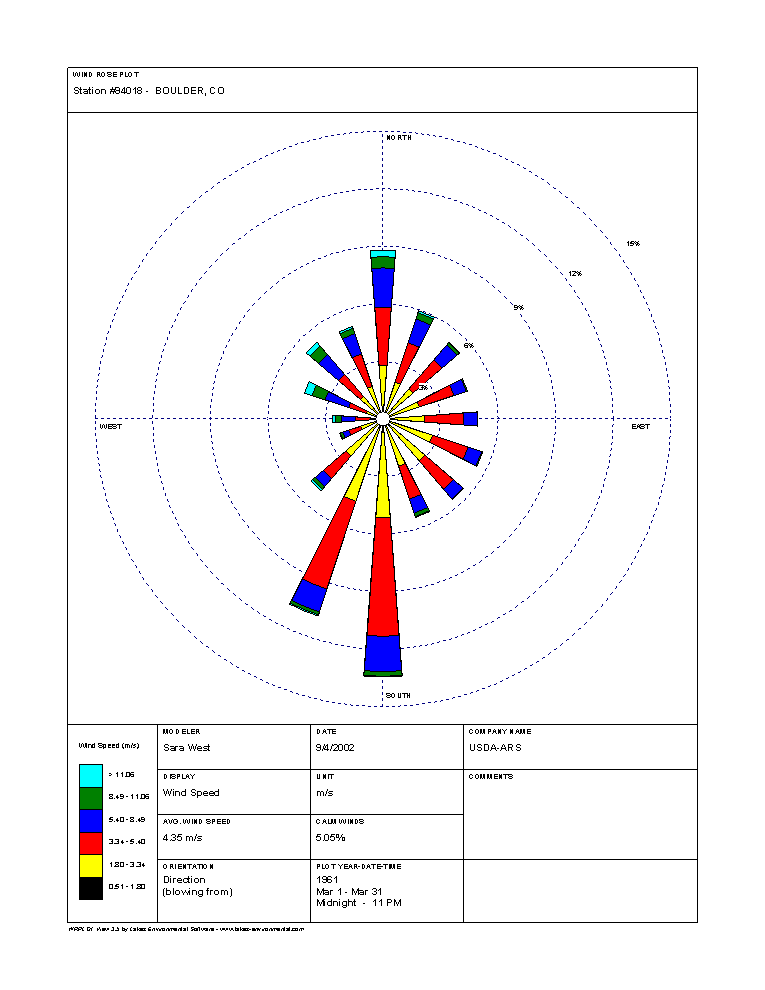
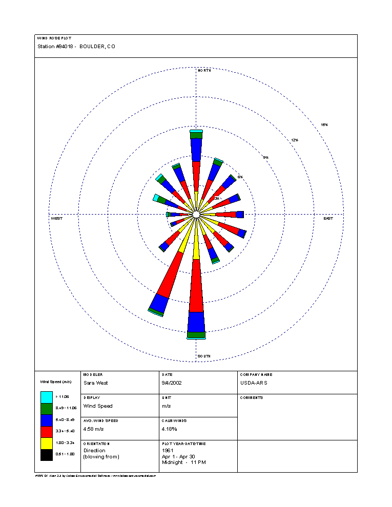
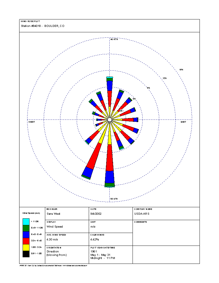
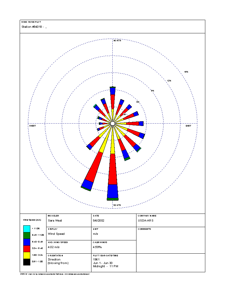
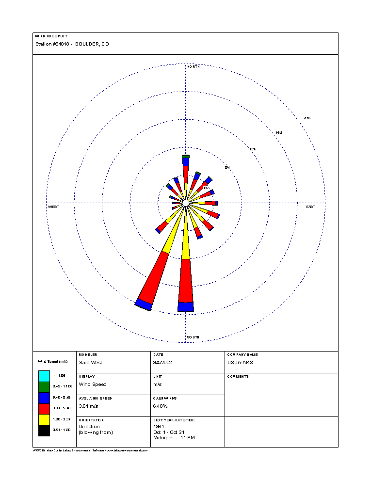
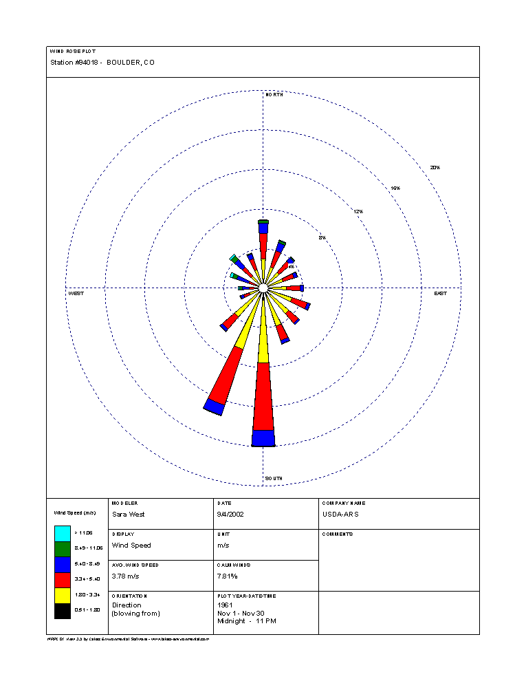
Boulder, CO Wind Roses
Wind roses for Boulder by month that show the prevailing wind directions and speeds. Provided by the National Resource Conservation Service.