Marine Heatwaves
Overview
Marine heatwaves are periods of persistent anomalously warm ocean temperatures, which can have significant impacts on marine life as well as coastal communities and economies. Scientists at PSL are working to characterize marine heatwaves, understand how they form and dissipate, and predict them in advance. On this page, we will provide current ocean maps, forecasts of heatwaves, interactive tools for users to explore ocean heatwaves themselves, links to research results and to webpages at other institutions.
Remove long-term temperature trends?

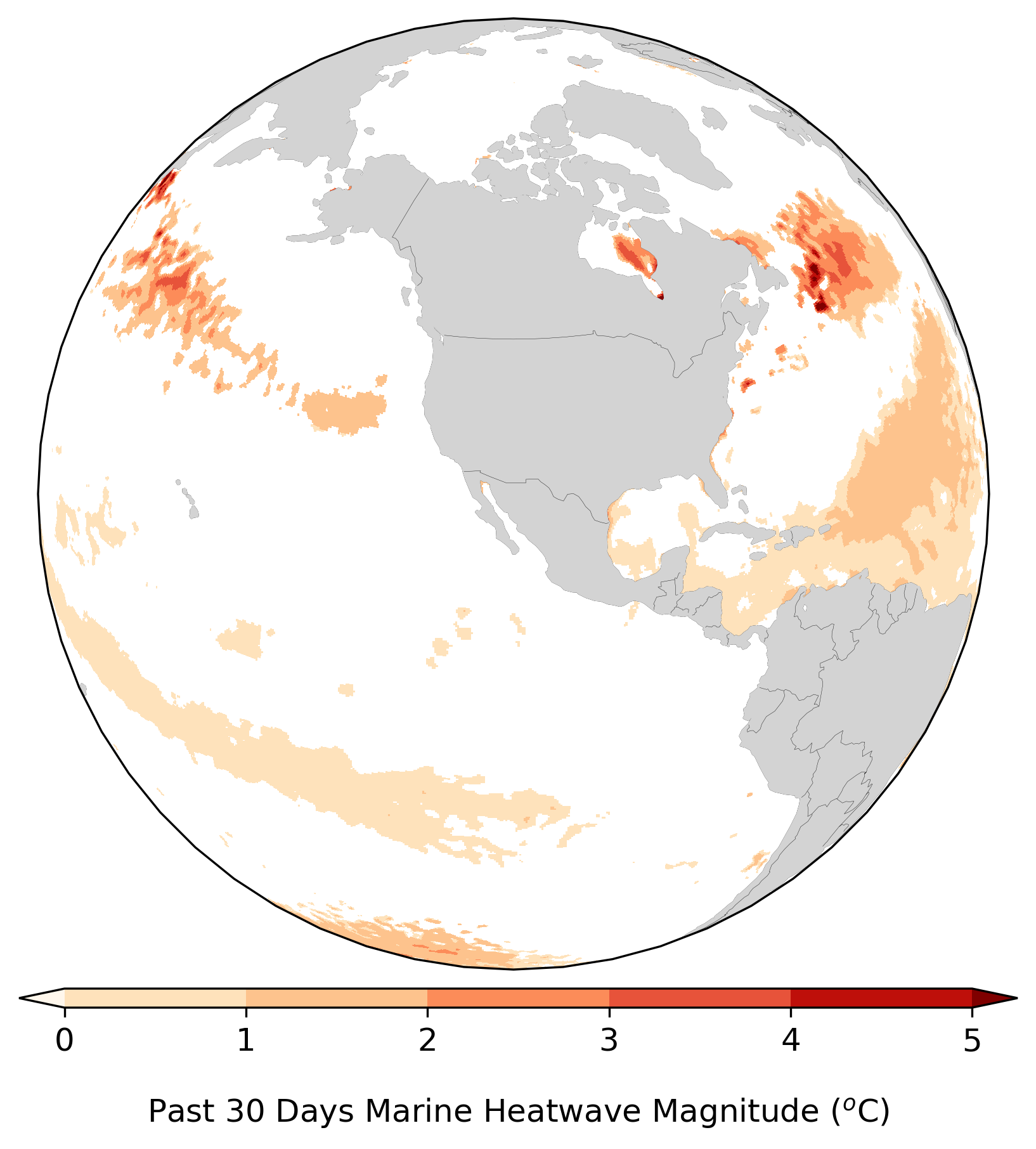
Click on the image to view global map!
Observed Condition
To reference plot in a publication, please cite as "Image provided by the NOAA Physical Sciences Laboratory, Boulder, Colorado from the website at https://psl.noaa.gov/ ".
Q&A for the interactive tool
- How to interact with the map
- What is a percentile and how is it used to define a MHW
- Why does the sea surface temperature (SST) trend matter
- How to interact with the time series
- What are the rankings
Further questions please contact psl.marineheatwaves@noaa.gov
Forecasts
To reference plot in a publication, please cite as "Image provided by the NOAA Physical Sciences Laboratory, Boulder, Colorado from the website at https://psl.noaa.gov/ ".
Q&A for the forecast tool
- How to interact with the map
- What is marine heatwave
- What models are used to generate the prediction
- Why does the sea surface temperature (SST) trend matter
- What is prediction skill
Further questions please contact psl.marineheatwaves@noaa.gov
High Resolution Sea Surface Temperature
User Options
| Dataset* : | |
| Region† : | |
| Frequency : | |
| Statistic : | |
| Year* : | |
| Month* : | |
| Day* : | |
| Dataset* : | |
| Region† : | |
| Data1 : | |
| Frequency : | |
| Statistic : | |
| Year* : | |
| Month* : | |
| Day* : | |
| Data2 : | |
| Frequency : | |
| Statistic : | |
| Year* : | |
| Month* : | |
| Day* : | |
| Region† : | |
| Dataset1 : | |
| Dataset* : | |
| Frequency : | |
| Year* : | |
| Month* : | |
| Day* : | |
| Dataset2 : | |
| Dataset* : | |
| Frequency : | |
| Year* : | |
| Month* : | |
| Day* : | |
|
Please allow 1 min
for some large LMEs.
|
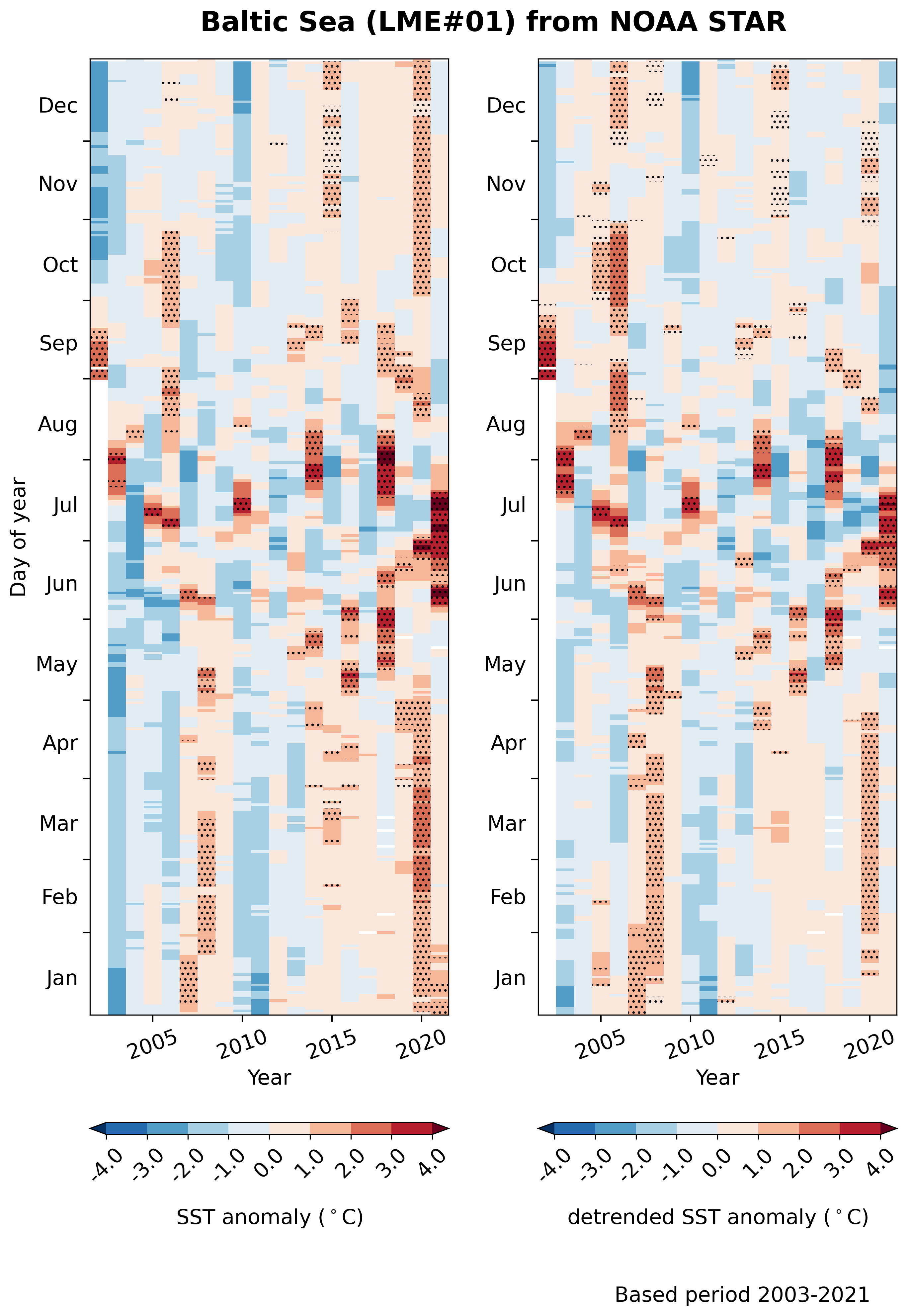
Time series from:
| Region† : | |
| Longitude : | |
| Latitude : | |
| Dataset* : | |
| Frequency : | |
| Statistic : | |
| Start Year* : | |
| End Year* : | |
| MHW : | |
Visualize time series in:
# presents the time series in a 2-D plan with year in x-axis, day-of-year in y-axis, and color showing the magnitude of the variables.
† (LMEs) map showing the associated ID number and name.
* availability for date (year, month, day) options.


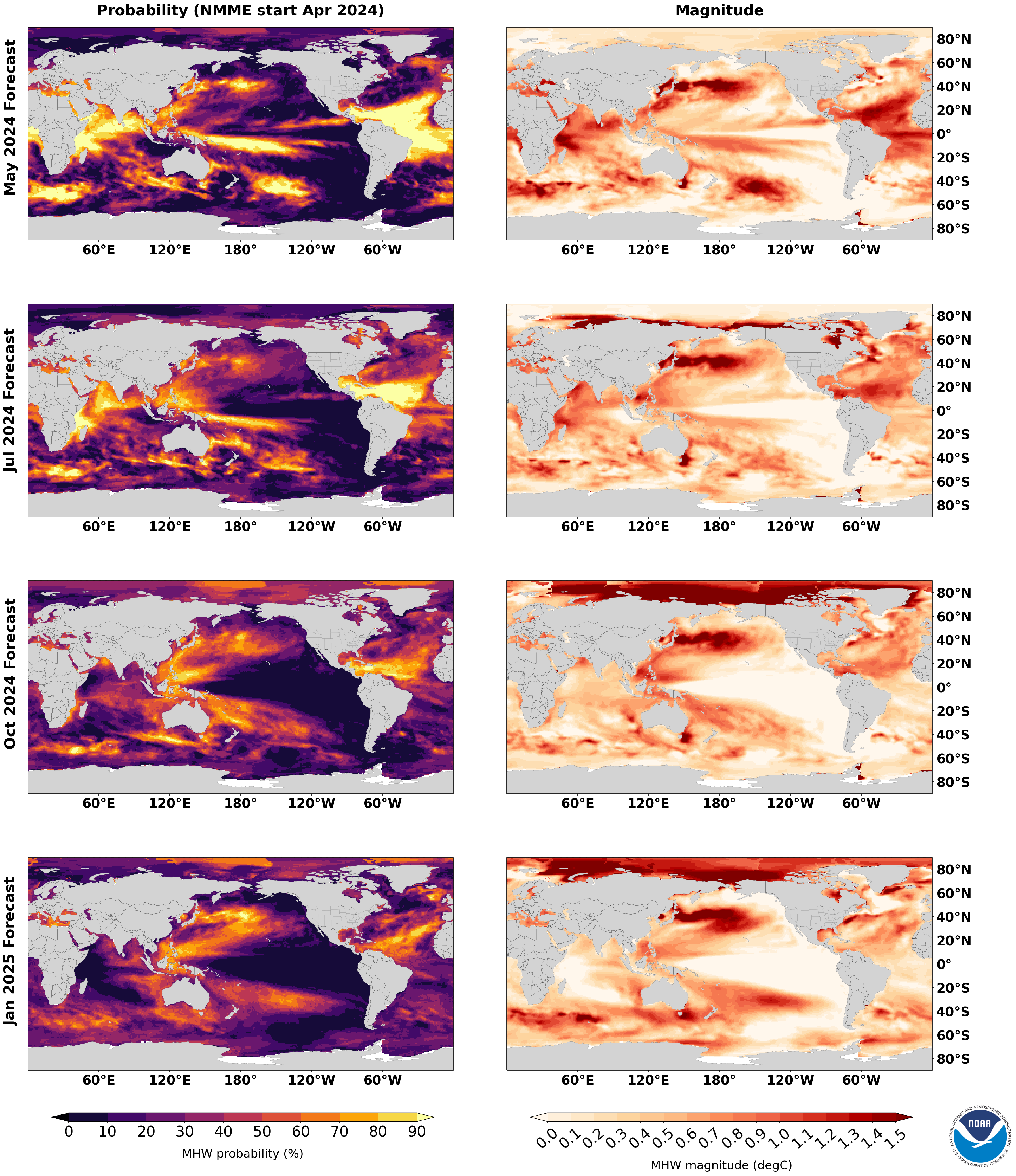
Marine Heatwave Forecast Monthly Report
Global Marine Heatwave Forecast Discussion
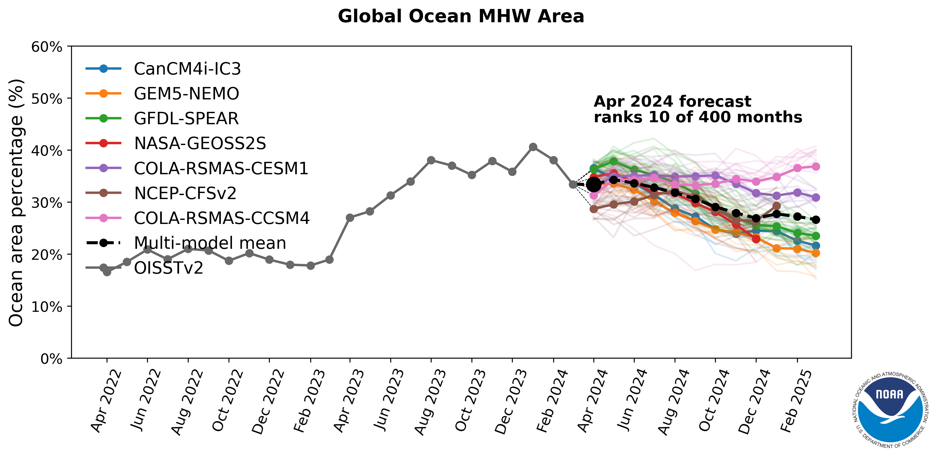
Observed and forecasted values include the effects of long-term warming. Values with the long-term warming trend removed are in brackets.
Current marine heatwave conditions:
In June 2026, 33% [22%] of the global ocean experienced marine heatwaves (MHWs), which ranked 12th [15th] among all months since 1991.
Currently, MHWs are present in the Eastern Pacific, the Sea of Japan and Kuroshio Extension region, the Northeast Atlantic and Norwegian Sea, the Mediterranean Sea, the Tasman Sea, and scattered regions of the Southern Ocean.
Marine heatwave forecasts:
Global MHW coverage is predicted to reach 45% [>30%] in boreal winter 2025-2026, which would be the highest since at least 1991. Below is a regionally refined focus:
- Tropical Pacific - With an ongoing El Niño event predicted to peak in boreal winter, MHW likelihoods throughout the remainder of 2026 are very high in the Eastern Tropical Pacific (90-100% [90-100%]; high confidence).
- Northeast Pacific - High MHW likelihoods are forecast off the California and Baja California coasts through the end of the year (70-100% [70-90%]; high confidence), with lower but still elevated likelihoods off Oregon and Washington (30-70% [20-50%]; low-medium confidence).
- Central and Western North Pacific - Forecast MHWs probabilities in the Kuroshio Extension region remain elevated through September (50-80% [30-60%]; low-medium confidence).
- Northeast Atlantic - Continued high MHW likelihoods are predicted in the Northeast Atlantic through October (40-60% [10-40%]; low confidence).
- Mediterranean Sea - MHW likelihoods in the Mediterranean are declining over the coming months, reaching 50-70% ([10-30%]; low confidence) in September.
- Indian Ocean - MHW likelihoods are very high in the western and northern Indian Ocean through October (90-100% [80-100%]; medium confidence).
- Tasman Sea - Continued MHW activity is likely in the Tasman Sea through October (70-100% [30-50%]; medium-high confidence)
- Southern Ocean - Areas of high MHW probabilities over the next several months are scattered across all sectors of the Southern Ocean, with the highest likelihoods southwest of South America and southeast of Africa (80-100% [80-100%]; low-medium confidence).
How confidence levels are determined
Marine Heatwave Maps
Remove long-term temperature trends?
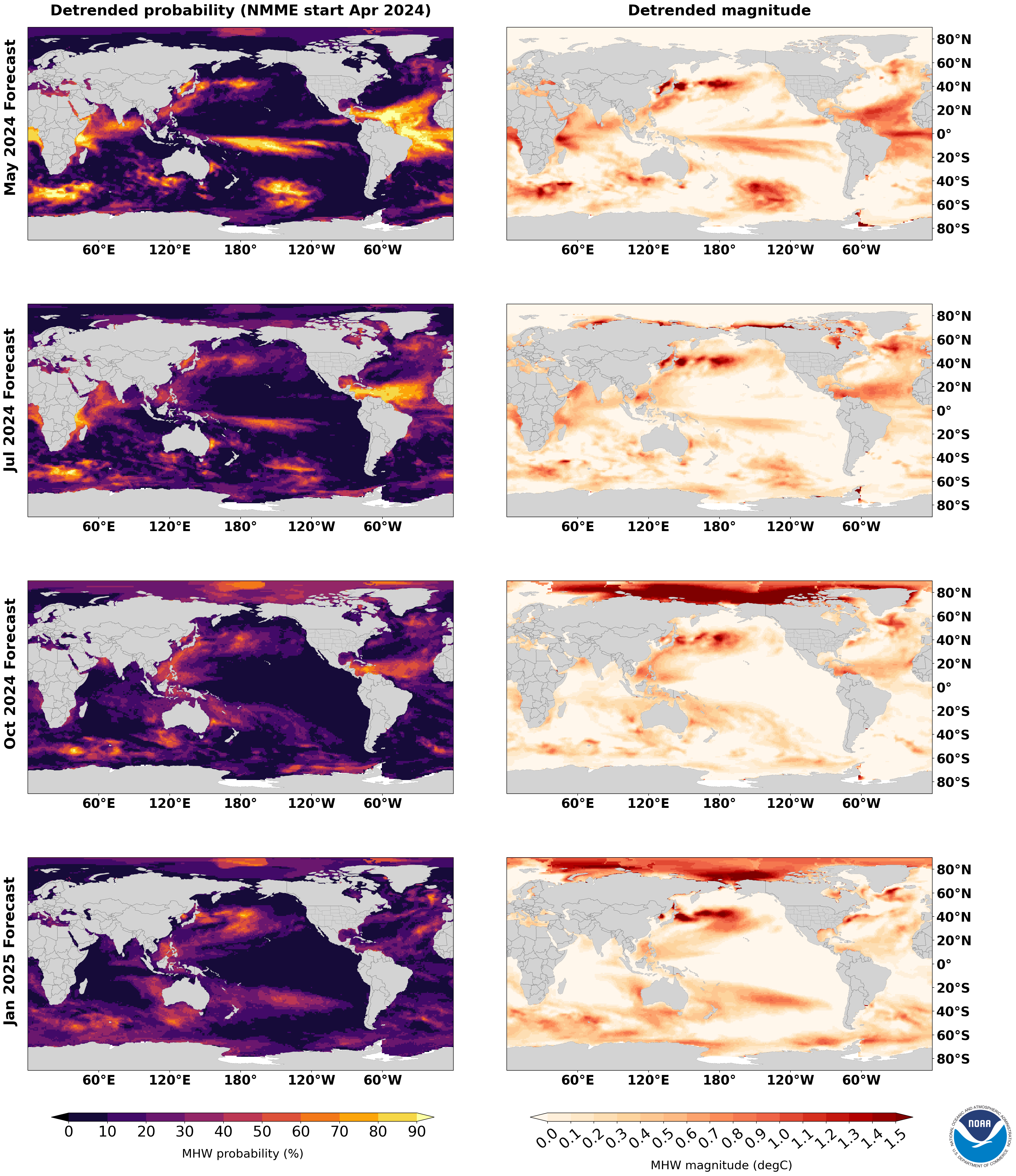
Click on the image to have a full screen view!
Marine Heatwave Area Percentage - Monthly Forecast
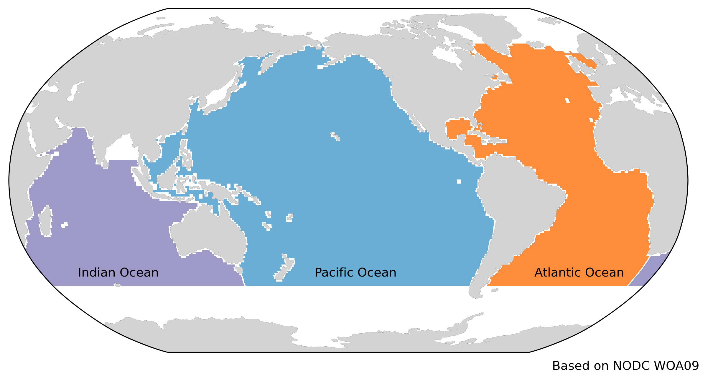
How the ocean basins are defined
Remove long-term temperature trends?
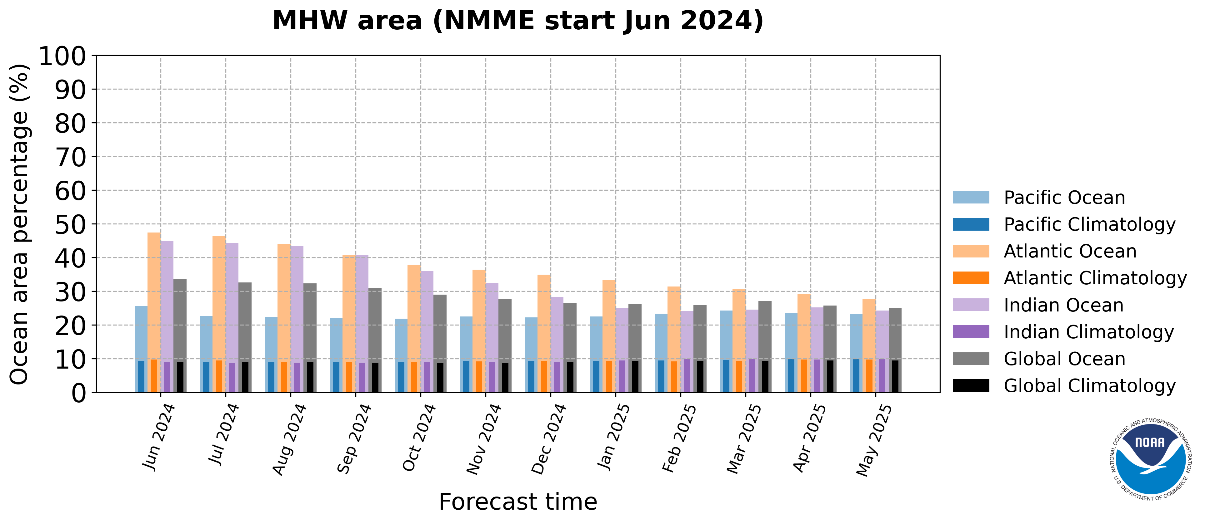
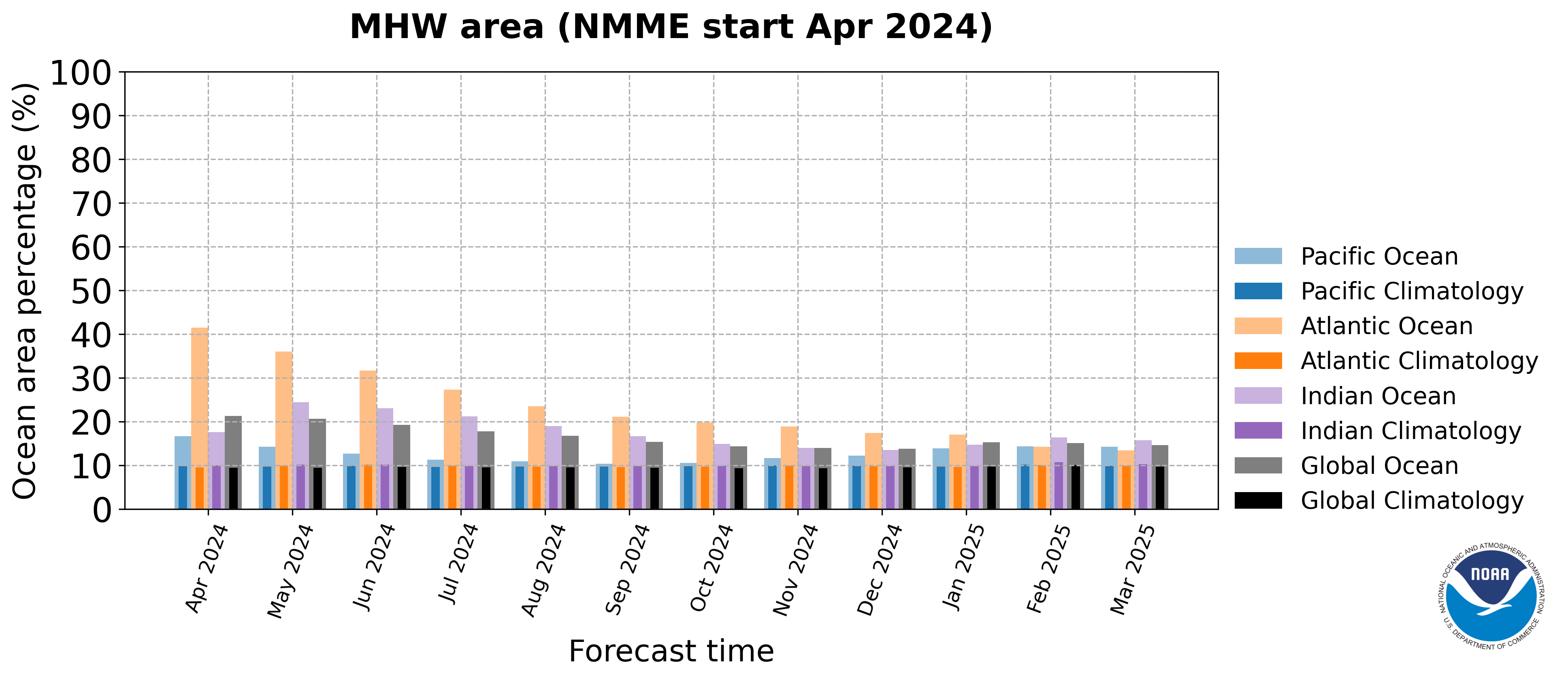
Click on the image to have a full screen view!
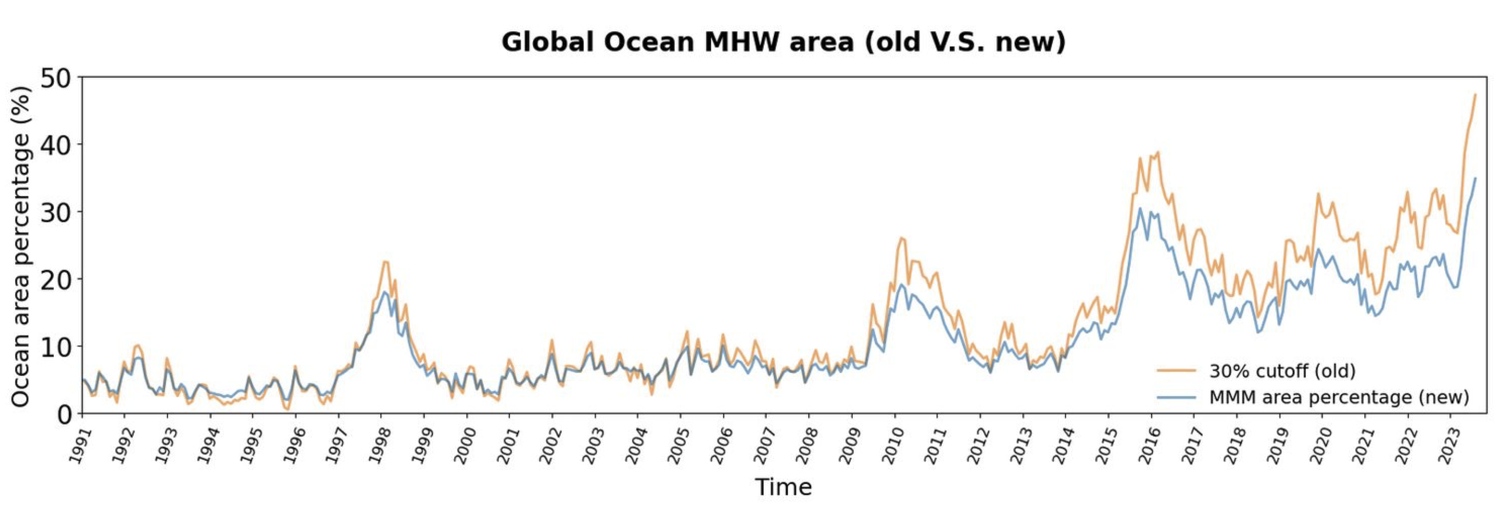
Marine Heatwave Area Percentage - Historical Record
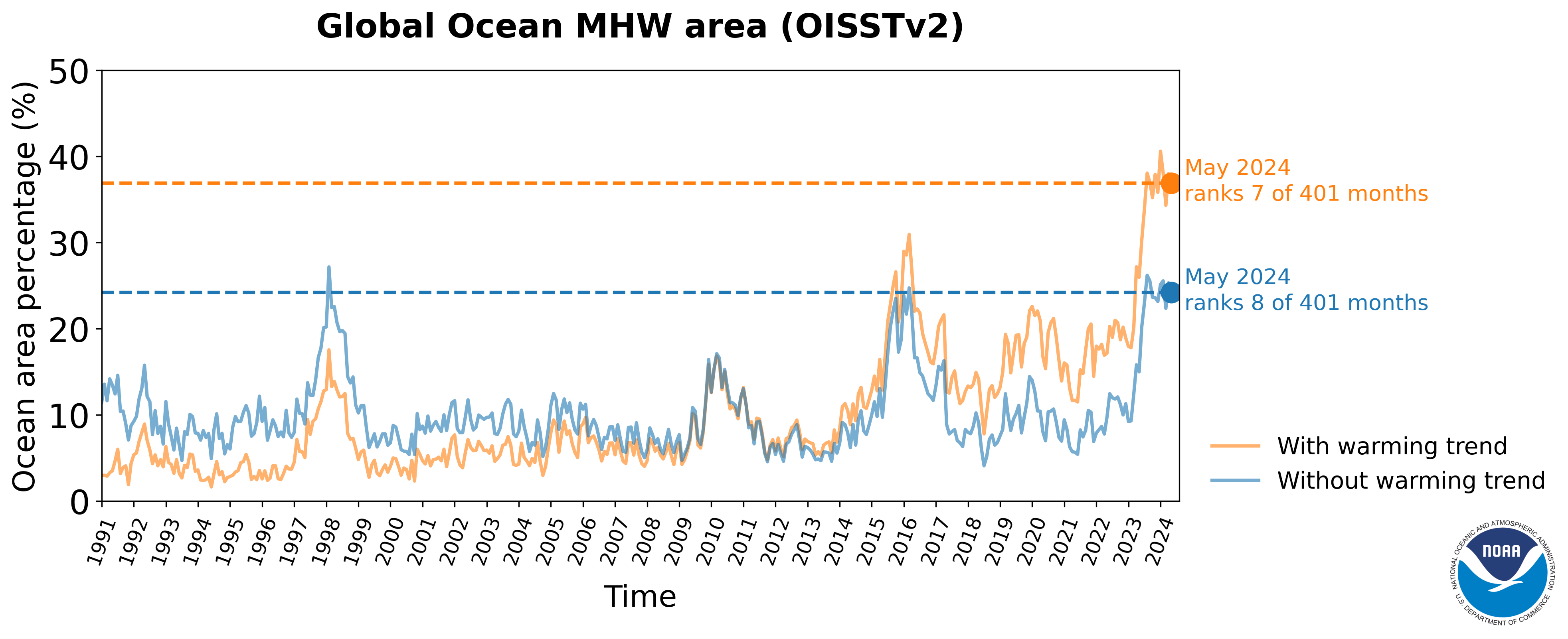
Click on the image to view forecast plume!
Explore
Web Based Tools for looking at Marine Heatwaves
PSL has several web-based tools for plotting and analyzing gridded datasets and timeseries. With these tools, you can extract time-series from different regions, plots maps of means and anomalies, create correlations maps, and analysis time-series. We are also expanding upon what these tools can do.
List of tools
- WRIT Ocean Maps and Vertical Crossections
Allows users to make maps and vertical cross-sections from various reanalyses. Statistics include means, anomalies and climatologies. Users can also difference the various reanalyses for all three types of statistics (for any overlapping date in the reanalyses). Composites (averaging multiple dates) are also available.
- WRIT Ocean Time-series Extraction and Analysis
- WRIT Ocean Correlation Maps Vertical Crossections.
Calculates correlations (and regressions) of the reanalysis and observational dataset with supplied atmospheric/ocean indices or user uploaded time-series. Users can plot correlations at different lead/lags. They can also create vertical cross-section correlation plots.
Extracts timeseries at specified latitude/longitude or latitude/longitude ranges and either plots the time-series, time-series differences, and scatter plots. Various statistics are returned in addition to numeric values of the time-series plotted. Ability to plot and compare climate index time-series such as the PNA or Niño3.4 or upload your own.
PSL Publications
Refereed Papers
- Xu, T., M. Newman, A. Capotondi, S. Stevenson, E. Di Lorenzo, and M. A. Alexander (2022): An increase in marine heatwaves without significant changes in surface ocean temperature variability, Nat. Commun., 13, 7396, https://doi.org/10.1038/s41467-022-34934-x.
- Jacox, M. G., M. A. Alexander, D. J. Amaya, E. Becker, S. J. Bograd, S. Brodie, E. L. Hazen, M. Pozo Buil, and D. Tommasi (2022): Global seasonal forecasts of marine heatwaves, Nature, 604, 486-490, http://doi.org/10.1038/s41586-022-04573-9.
- A. Capotondi, M. Newman, Xu, T., and E. Di Lorenzo (2022): An Optimal Precursor of Northeast Pacific Marine Heatwaves and Central Pacific El Niño Events, Geophys. Res. Lett., 49 (5), e2021GL097350, https://doi.org/10.1029/2021GL097350.
- Amaya, D. J., M. A. Alexander, A. Capotondi, C. Deser, K. Karnauskas, A. J. Miller and N. Mantua (2021): Are Long-Term Changes in Mixed Layer Depth Influencing North Pacific Marine Heatwaves?. Bull. Amer. Meteor. Soc., 102 (1), S59-S66, https://doi.org/10.1175/BAMS-D-20-0144.1.
- Xu, T., M. Newman, A. Capotondi and E. Di Lorenzo (2021): The Continuum of Northeast Pacific Marine Heatwaves and Their Relationship to the Tropical Pacific. Geophys. Res. Lett., 48 (2), 202GL090661, https://doi.org/10.1029/2020GL090661.
- Jacox, M. G., M. A. Alexander, S. J. Bograd and J. D. Scott (2020): Thermal displacement by marine heatwaves. Nature, 584, 82-86, https://doi.org/10.1038/s41586-020-2534-z.
- Jacox, M. G., D. Tommasi, M. A. Alexander, G. Hervieux and C. A. Stock (2019): Predicting the Evolution of the 2014–2016 California Current System Marine Heatwave From an Ensemble of Coupled Global Climate Forecasts. Front. Mar. Sci., 6, 497, https://doi.org/10.3389/fmars.2019.00497.
- Alexander MA, JD Scott, KD Friedland, KE Mills, JA Nye, AJ Pershing, AC Thomas, (2018): Projected sea surface temperatures over the 21st century: Changes in the mean, variability and extremes for large marine ecosystem regions of Northern Oceans. Elementa: Science of the Anthropocene, 6(1):9, http://doi.org/10.1525/elementa.191.
- Scannell, H. A., A. J. Pershing, M. A. Alexander, A. C. Thomas and K. E. Mills (2016): Frequency of marine heatwaves in the North Atlantic and North Pacific since 1950. Geophys. Res. Lett., 43 (5), 2069-2076, https://doi.org/10.1002/2015GL067308.
Marine Heatwave Related Datasets
Marine Heatwave Datasets
- Marine Heatwave prediction from 1991-2020 (with trend)
- Marine Heatwave prediction from 1991-2020 (detrended)
- Ocean and sea ice mask
- Extended Marine Heatwave prediction starting 2021 (with trend)
- Extended Marine Heatwave prediction starting 2021 (detrended)
- Observed Sea Surface Temperature Anomaly (OISSTv2) starting 1990 (with trended)
- Observed Sea Surface Temperature Anomaly (OISSTv2) starting 1990 (detrended)
- Observed Marine Heatwave threshold 90% (OISSTv2) starting 1990 (with trended)
- Observed Marine Heatwave threshold 90% (OISSTv2) starting 1990 (detrended)
SST Datasets at PSL
- NOAA OI SST Daily High Resolution.
From 1982, a gridded high resolution daily dataset from NOAA that continues to present.
- NOAA ERSST V5
From 1865, a gridded consistently analyzed monthly dataset from NOAA that continues to present. V3 and V4 are also available
- COBE SST
- COBE-2 SST
- ICOADS
- Kaplan SST
- NOAA OI V2
- NODC 1994 and 1998 atlasses
Ocean Reanalyses at PSL
Ocean Time-series at PSL
News
News Articles about the PSL Marine Heatwave Research and Products
- 06/09/2025: See How Marine Heat Waves Are Spreading Across the Globe (New York Times)
- 07/07/2023: Ocean warming since 1991 doubles the size of the marine heat wave forecasted for September 2023 (Climate.gov)
- 06/28/2023: Global ocean roiled by marine heatwaves, with more on the way (NOAA Research)
- 04/18/2023: El Niño is coming, and ocean temps are already at record highs – that can spell disaster for fish and corals (The Conversation)
- 05/03/2022: Marine heatwaves can be predicted ‘up to a year ahead’ (Carbon Brief)
- 04/28/2022: New research could lead to forecasting of future marine heat waves in the Pacific Northwest (King 5 News)
- 04/20/2022: Marine heatwaves are reliably forecast by climate models (Nature, News and Views)
- 04/20/2022: New Global Forecasts of Marine Heatwaves Foretell Ecological and Economic Impacts (NOAA Fisheries)
- 04/20/2022: Today’s seasonal climate models can predict ocean heat waves months in advance (Climate.gov)
- 04/20/2022: Abnormally warm water could get close to California coast soon (SF Chronicle)
- 04/20/2022: A first as the world warms: New forecasts could help predict marine heat waves (The Seattle Times)
Resources
Links
- The California Current Marine Heatwave Tracker
Developed by oceanographers from NOAA Fisheries' Southwest Fisheries Science Center as an experimental tool for natural resource managers, the California Current MHW Tracker is a program designed to understand, describe, and provide a historical context for the 2014-16 blob. It also produces a range of indices that could help forecast or predict future MHWs expected to impact the CA coast. (NOAA Integrated Ecosystem Assessment) - Marine Heatwave Monitoring and Forecast
Developed by oceanographers from NOAA/NCEP Climate Prediction Center, the webpage provides an overview on the marine heatwave diagnostics based on observational data and marine heatwave forecast based on NMME/CFSv2. (NOAA/NCEP Climate Prediction Center) - Ocean heat observations from NOAA's Global Ocean Monitoring and Observing Program (GOMO)
GOMO conducts long-term ocean observations that help with better prediction and preparation for the impacts of hotter seas, including rising coastlines, changing fisheries, coral bleaching, and more frequent storms. (NOAA Global Ocean Monitoring and Observing Program) - Marine Heatwaves Organization
From the Marine Heatwaves International Working Group which is dedicated to understanding marine heatwaves: their physical drivers, climatological properties, and ecological impacts. The webpage summarizes their research. (marineheatwaves.org) - California's Marine Heatwaves FAQ
Explore this FAQ to learn more about what is causing marine heatwaves and their impacts in California. (UC San Diego/Scripps) - Ocean Heatwaves
Key concepts about marine heatwaves with an emphasis on heatwaves and climate change. (Climate Central) - ENSO and Marine Heatwaves
An interview with two PSL scientists about marine heatwaves, what causes them, how they are impacted by ENSO and how climate change might impact their frequency, among other topics. (Climate.gov) - Looking back at the BLOB: Marine Heatwave
A history of the development of and the demise of the famous "Blob", the 2015-16 heat wave in the NE Pacific ocean. (NOAA Fisheries News)
Open Science
- Pythia Cookbook on Marine Heatwave Marine Heatwaves Cookbook
Code
- Python code that defines marine heatwaves from SST data
This is a Research and Development Application