AQPI
Advanced Quantitative Precipitation Information
About
When big storms hit California, current technology does not provide forecasters with the detailed information needed to inform reservoir operations, flood protection, combined sewer-stormwater systems and emergency preparedness. Accurate and timely precipitation information is critical for making decisions regarding public safety, infrastructure operations, and resource allocations.
Standard weather radars, originally designed to look up into Midwest thunderstorms, are often unable to give an accurate picture of what is happening just above the complex landscape of California’s coastal mountain ranges, where precipitation can be heaviest. Improved precipitation monitoring and prediction in the San Francisco Bay region can enhance public safety through early warning and storm tracking when hazardous weather events come onshore.
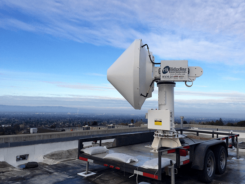
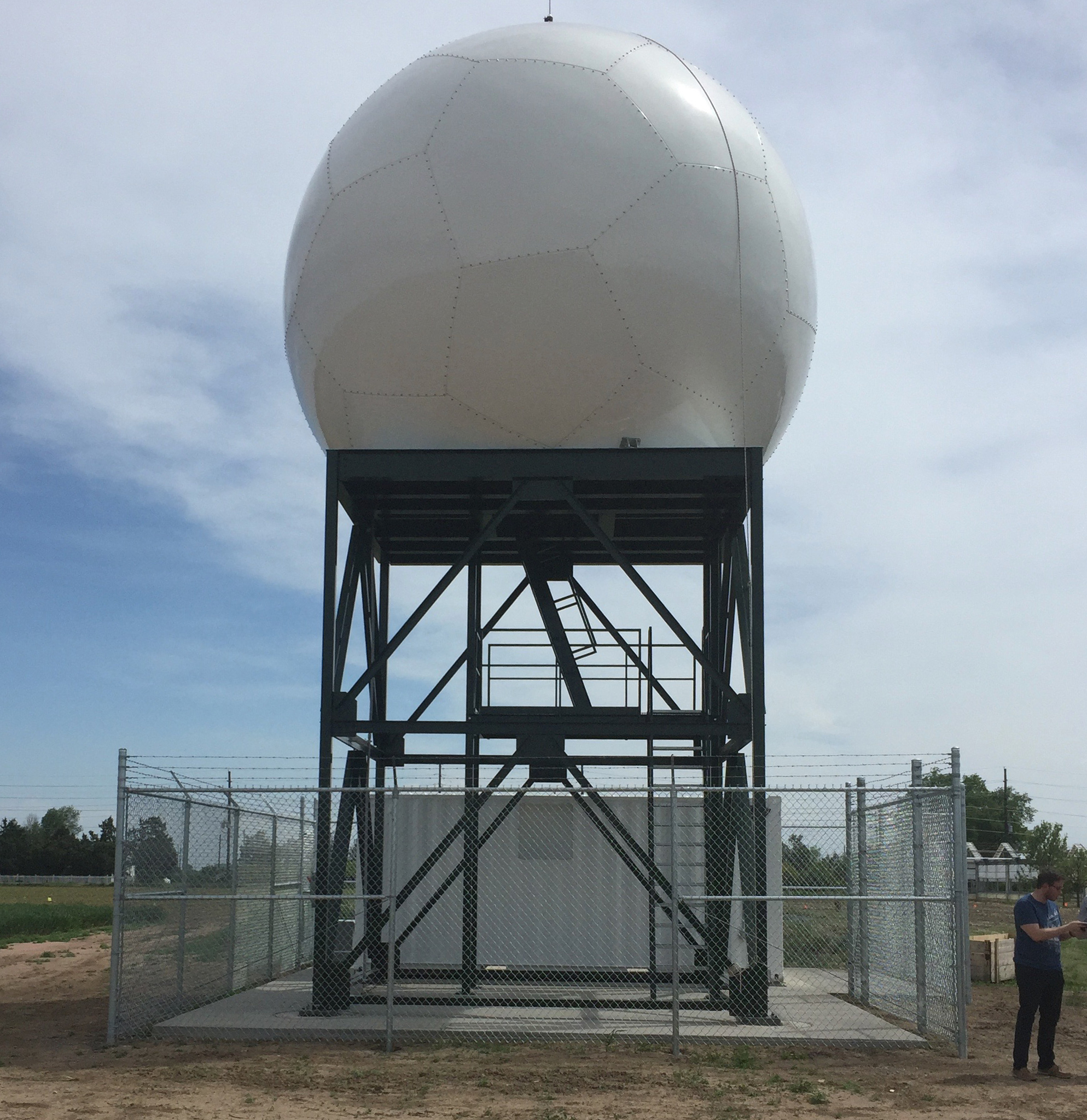
Advanced Quantitative Precipitation Information (AQPI) is a regional project awarded to NOAA and collaborating partners by the California Department of Water Resources. The AQPI system consists of improved weather radar data for precipitation estimation and short-term nowcasting (0-1 hours); additional surface measurements of precipitation, streamflow and soil moisture; and a suite of forecast modeling systems to improve lead time on precipitation and coastal Bay inundation from extreme storms–especially moisture-laden atmospheric rivers.
Go to AQPI Real-Time Radar Display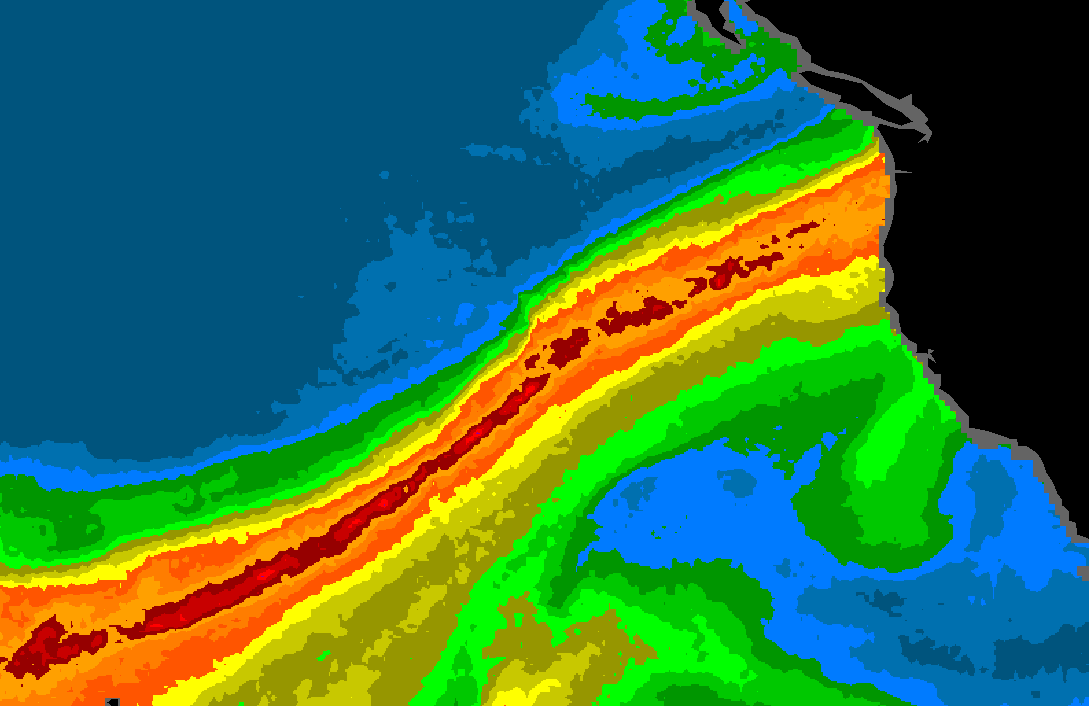
Partners
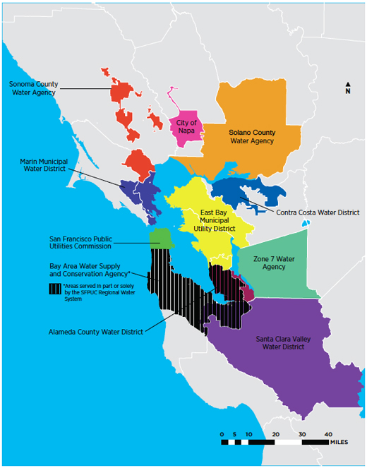
AQPI is a cooperative federal-state-local research and development partnership aimed at improving prediction of hazardous weather and flooding events to enhance protection of life, property and critical infrastructure in the nine-county San Francisco Bay area. Funded by a grant from California's Department of Water Resources and led by NOAA, AQPI will apply cutting-edge weather forecasting technology to address the diverse public safety, infrastructure and environmental concerns of emergency managers, water system operators and public utilities in the region.
Federal |
|---|
 NOAA Research and National Weather Service
|
 US Geological Survey
|
State |
|---|
 California Department of Water Resources
|
 Cooperative Institute for Research in the Atmosphere
|
 Scripps Center for Western Weather & Water Extremes
|
Technology
AQPI includes a combination of observations and forecast models to improve prediction of precipitation, streamflow and coastal flooding, which builds on an existing network established by NOAA, DWR and Sonoma Water to monitor extreme precipitation in California. Highlights of AQPI include:
- Five new state-of-the-art radar systems to improve monitoring of precipitation offshore and within the Bay region
- High-resolution precipitation forecasts
- Coastal flooding, storm surge, and tributary streamflow forecasts
NOAA Contributions
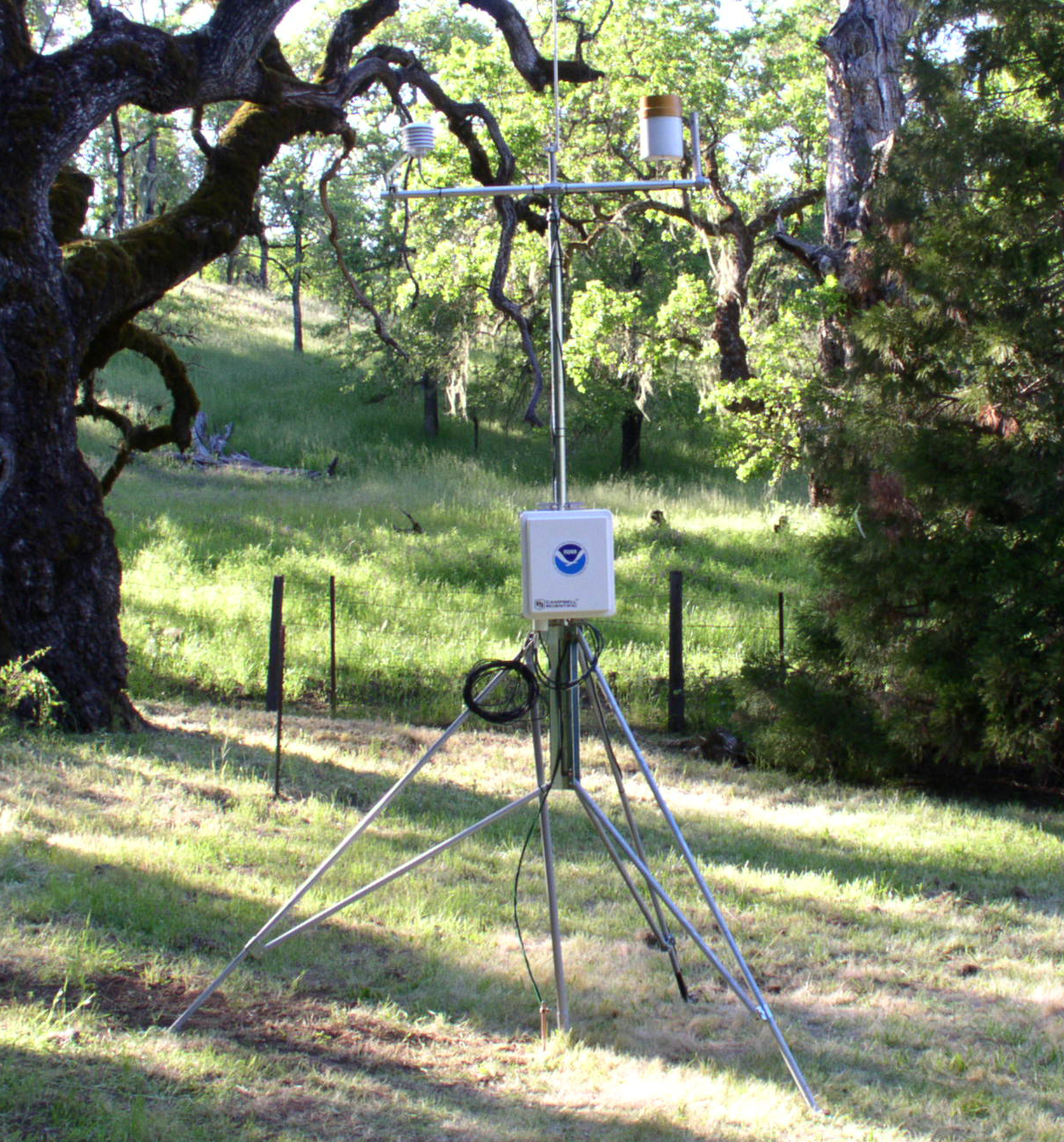
- New Surface Meteorological Sites
- A suite of forecast modeling systems including:
CIRA Contributions
- Four X-Band radar systems
- One C-Band radar system
- Radar system interface
USGS Contributions
- USGS Coastal Storm Modeling System (CoSMoS)
System
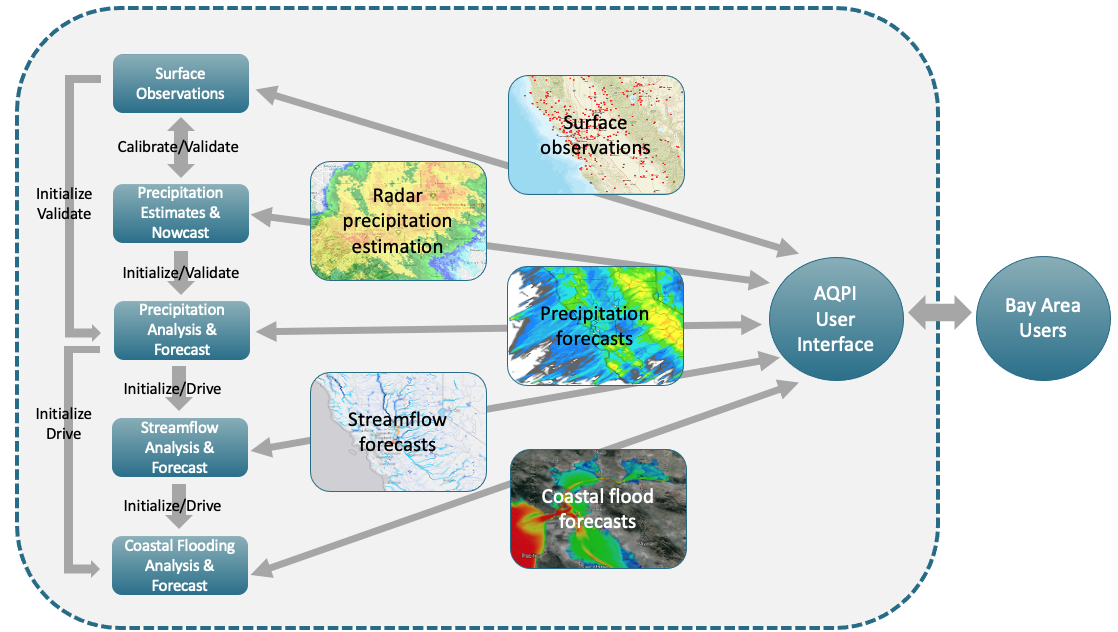
The AQPI System is a precipitation monitoring, alerting, and hydrological information system tailored for operational use by water agencies in the San Francisco Bay (SF-Bay) area. What to monitor, when to alert, and what information to provide will be driven and may be unique to each water agency. Water agency users have access to the following core data:
- Observations
- Precipitation Estimates
- Precipitation Nowcast
- Precipitation Forecast
- River Stage and Flow Forecasts
- Coastal Inundation Forecasts
The AQPI system provides a complete coupling of water flowing from cloud to ground to river to ocean and the tailoring of information for water agency use.
Figure: Simplified AQPI System Diagram
How the System was Built
The AQPI system was built to meet SF-Bay area user needs through a highly collaborative process that depends on early and ongoing feedback from users. We started with initial user requirements, designed to these requirements, developed, and tested the system. The users then test drove and provided feedback on the system, which was used to develop the next version.
The core requirements of the AQPI system were the observations and forecasts of precipitation and hydrology information to support the needs of SF-Bay area water agencies and managers.
Data Access
The AQPI System was built by NOAA's Global Systems Laboratory. The system website, now hosted by CIRA at Colorado State University, allows users access to graphical real-time forecast and observational data and the ability to provision data transfers to inform their operations.
Access the Data at CIRAAnticipated Benefits
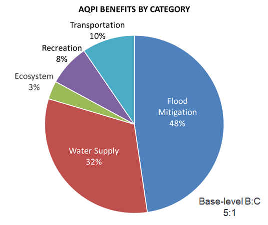
The AQPI System can aid water managers in securing water supplies while mitigating flood risk and minimizing potential water quality impacts to the Bay from storm runoff and combined sewer overflows. The system can be expected to provide benefits exceeding costs by a ratio of at least 4:1. These benefits accrue through:
- Avoided flood damage costs from early warnings.
- Forecast-based operations to maximize reservoir capture for water supply and fisheries flows.
- Minimization of water quality impacts from combined sewer overflows during storms.
- Enhancement of public safety for the various transportation modes (pedestrian, highways, marine and airports).
Science
AQPI builds on over a decade of NOAA research on extreme precipitation in California, including the Bay area. This research has led to an extensive observational network supported by NOAA, the California Department of Water Resources, and the Sonoma Water Agency. Assets from this observational network leveraged by AQPI include: Atmospheric River Observatories, soil moisture, surface meteorology, wind profilers, and snow level radars.
AQPI also includes new observations and forecast modeling to improve monitoring and prediction of precipitation, streamflow, and coastal inundation in the San Francisco Bay region. New AQPI observations:
- Five state of the art weather radar systems
- Streamflow and surface meteorological sites
- NOAA HRRR Model for atmospheric forecasts
- NOAA National Water Model for hydrologic forecasts
Areas of Interest
Project Overview
System Integration
Atmospheric Modeling
Coastal Flood Model
Radar Precipitation Monitoring
Tributary Hydrology
Related Publications
- Biswas, S. K.,R. Cifelli and V. Chandrasekar (September 2022 ONLINE): Quantitative Precipitation Estimation using X-Band Radar for Orographic Rainfall in the San Francisco Bay Area. IEEE Trans. Geosci. Remote Sens., https://doi.org/10.1109/TGRS.2022.3207829
- Bytheway, J. L., M. Hughes, R. Cifelli, K. Mahoney, and J. M. English (January 2022): Demonstrating a Probabilistic Quantitative Precipitation Estimate for Evaluating Precipitation Forecasts in Complex Terrain. Weather Forecast., 37, 45-64, https://doi.org/10.1175/WAF-D-21-0074.1.
- Cifelli, R., V. Chandrasekar, L. Herdman, D. D. Turner, A. B. White, et al. (October 2022 ONLINE): Advanced Quantitative Precipitation Information: Improving Monitoring and Forecasts of Precipitation, Streamflow, and Coastal Flooding in the San Francisco Bay Area. Bull. Amer. Meteor. Soc., https://doi.org/10.1175/BAMS-D-21-0121.1
- Chen, H., L. Sun, R. Cifelli, and Pingping Xie (August 2021): Deep learning for bias correction of satellite retrievals of orographic precipitation. IEEE Trans. Geosci. Remote Sens., https://doi.org/10.1109/TGRS.2021.3105438.
- Cifelli, R., L. E. Johnson, J. Kim, T. Coleman, G. Pratt, L. Herdman, R. Martyr-Koller, J. A. FinziHart, L. Erikson, P. Barnard, and M. Anderson (January 2021): Assessment of Flood Forecast Products for a Coupled Tributary-Coastal Model. Water, 13, 312, https://doi.org/10.3390/w13030312.
- English, J. M., D. D. Turner, T. I. Alcott, W. R. Moninger, J. L. Bytheway, R. Cifelli, R., and M. Marquis (December 2021). Evaluating Operational and Experimental HRRR Model Forecasts of Atmospheric River Events in California, Weather Forecast., 36(6), 1925-1944, https://doi.org/10.1175/WAF-D-21-0081.1.
- Ma, Y., V. Chandrasekar, H. Chen, and R. Cifelli (July 2021): Quantifying the potential of AQPI gap-filling radar network for streamflow simulation through a WRF-Hydro experiment, J. Hydrometeor., https://doi.org/10.1175/JHM-D-20-0122.1.
- Moore, B. J., White, A. B., and D. J. Gottas (July 2021). Characteristics of long-duration heavy precipitation events along the West Coast of the United States. Mon. Wea. Rev., https://doi.org/10.1175/MWR-D-20-0336.1.
- Bytheway, J. L., M. Hughes, K. Mahoney, and R. Cifelli (April 2020): On the uncertainty of high resolution hourly Quantitative Precipitation Estimates in California. J. Hydrometeor., 21(5), 865–879, https://doi.org/10.1175/JHM-D-19-0160.1.
- Chen, H., R. Cifelli and A. White (March 2020): Improving Operational Radar Rainfall Estimates Using Profiler Observations Over Complex Terrain in Northern California. IEEE Transactions on Geoscience and Remote Sensing, 58(3), 1821-1832, https://doi.org/10.1109/TGRS.2019.2949214.
- Chen, H., V. Chandrasekar, R. Cifelli, and P. Xie (Feburary 2020): A Machine Learning System for Precipitation Estimation Using Satellite and Ground Radar Network Observations. IEEE Trans. Geosci. Remote Sens., 58(2), 982-994, https://doi.org/10.1109/TGRS.2019.2942280.
- Johnson, L. E., R. Cifelli, and A. White (December 2020): Benefits of an Advanced Quantitative Precipitation Information System. J. Flood Risk Mgt., 13(S1), e12573, https://doi.org/10.1111/jfr3.12573.
- Kim, J., L. Read, L. E. Johnson, D. Gochis, Rob Cifelli, and H. Han (May 2020): An experiment on reservoir representation schemes to improve hydrologic prediction: coupling the national water model with the HEC-ResSim, Hydrol. Sci. J., 65(10)https://doi.org/10.1080/02626667.2020.1757677.
- Tehranirad, B., L. Herdman, K. Nederhoff, L. Erikson, R. Cifelli, G. Pratt, M. Leon, and P. Barnard (September 2020): Effect of Fluvial Discharges and Remote Non-Tidal Residuals on Compound Flood Forecasting in San Francisco Bay. Water, 12(9), 2481, https://doi.org/10.3390/w12092481
- Bytheway, J. L., M. Hughes, K. Mahoney, and R. Cifelli (March 2019): A multiscale evaluation of multisensor quantitative precipitation estimates in the Russian River Basin. J. Hydrometeor., 20, 447–466, https://doi.org/10.1175/JHM-D-18-0142.1.
- Chen, H., R. Cifelli, V. Chandrasekar, and Y. Ma (December 2019): A Flexible Bayesian Approach to Bias Correction of Radar-derived Precipitation Estimates over Complex Terrain: Model Design and Initial Verification. J. Hydrometeor., 20, 2367–2382, https://doi.org/10.1175/JHM-D-19-0136.1.
- Han, H., J. Kim, V. Chandrasekar, J. Choi, and S. Lim (August 2019): Modeling Streamflow Enhanced by Precipitation from Atmospheric River Using the NOAA National Water Model: A Case Study of the Russian River Basin for February 2004. Atmosphere, 10, 466, https://doi.org/10.3390/atmos10080466.
- Kim, J., H. Han, L. E. Johnson, S. Lim, and R. Cifelli (October 2019): Hybrid Machine Learning Framework for Hydrological Assessment. J. Hydrol., 577, 123913, https://doi.org/10.1016/j.jhydrol.2019.123913.
- Kim, J., L. Johnson, R. Cifelli, A. Thorstensen, and V. Chandrasekar (December 2019): Assessment of antecedent moisture condition on flood frequency: An experimental study in Napa River Basin, CA. J. Hydrol. Reg. Studies, 26, 100629, https://doi.org/10.1016/j.ejrh.2019.100629.
- Cifelli, R., V. Chandrasekar, H. Chen, and L. E. Johnson (May 2018): High Resolution Radar Quantitative Precipitation Estimation in the San Francisco Bay Area: Rainfall Monitoring for the Urban Environment. J. Meteor. Soc. Japan, 96A, 141–155, https://doi.org/10.2151/jmsj.2018-016.
- Herdman, L., L. Erikson, and P. Barnard (December 2018): Storm Surge Propagation and Flooding in Small Tidal Rivers During Events of Mixed Coastal and Fluvial Influence. J. Marine Sci. Eng., 6(4), 158, https://doi.org/10.3390/jmse6040158.
User Resources
Backgrounders
User Group Meetings
| Event | Date | Location | Materials | Recordings |
|---|---|---|---|---|
| User Group #3 | 12/08/21 | Online | Slides | Meeting |
| User Group #2 | 05/18/20 | Online | Agenda & Talks | Full Day |
| User Group #1 | 01/24/20 | Oakland, CA | Agenda & Talks | Morning | Afternoon |
Working Group Meetings
| Event | Date | Location | Materials | Recordings |
|---|---|---|---|---|
| Data Implementation #9 | 09/15/21 | Online | Agenda/Discussion Slides | Meeting |
| Data Implementation #8 | 08/18/21 | Online | Agenda | Meeting |
| Data Implementation #7 | 06/16/21 | Online | Discussion Slides | Meeting |
| Data Implementation #6 | 04/21/21 | Online | Discussion Slides | Meeting |
| Data Implementation #5 | 03/24/21 | Online | Discussion Slides | Meeting |
| Data Implementation #4 | 01/20/21 | Online | Discussion Slides | Meeting |
| Data Implementation #3 | 10/21/20 | Online | Discussion Slides | Meeting |
| Data Implementation #2 | 09/23/20 | Online | Discussion Slides | Meeting |
| Data Implementation #1 | 08/19/20 | Online | Discussion Slides | Meeting |
| Watershed Modeling #2 | 06/17/20 | Online | Notes & Talks | Meeting |
| Watershed Modeling #1 | 05/20/20 | Online | Agenda & Talks | Meeting |
Media Resources
Media Contact: Theo.Stein@noaa.gov, NOAA Public Affairs Officer
History of AQPI
The seeds of AQPI were sown in the early 2000s with the deployment of advanced instrumentation and research studies focused on understanding extreme precipitation events in the CA coastal range and Sierra as part of NOAA's Hydrometeorology Testbed (HMT) program. Starting in 2008, NOAA’s Earth System Research Laboratory (ESRL) partnered with the California Department of Water Resources (CA-DWR) to address water resource and flood protection issues. As part of CA-DWR’s Enhanced Flood Response and Emergency Preparedness (EFREP) program, ESRL and CA-DWR are working to improve precipitation monitoring and prediction, especially for extreme events. The statewide deployment of observing systems and suite of highly detailed weather forecast models builds on lessons learned in NOAA's HMT.
The AQPI concept of using state-of-the-art radars to improve monitoring and short-term precipitation forecasts is a natural extension of the HMT and EFREP programs. In 2015 a proposal for a regional implementation of AQPI in the nine county region surrounding the San Francisco Bay area was submitted to a grant solicitation for CA-DWR Proposition 84 under the Bay Area Integrated Regional Water Management Plan, Bay Area Regional Climate Change Preparedness Program. The four year project was awarded by CA-DWR and officially kicked off October 1, 2017. It included funding for five new radar systems, several surface meteorological sites and integration precipitation, streamflow, and coastal flooding information into a system that can deliver data and customized products to end users.
Multimedia
- Handout: AQPI 2-Pager
- Video: AQPI at the Global Climate Action Summit (by Sonoma Water)
- Video: Advanced Quantitative Precipitation Information (by Sonoma Water)
