News

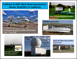
CalWater and HMT-West 2010/2011 observing systems
|
CalWater Science Workshop Held 4-5 October 2010
CalWater focuses on improving understanding of heavy precipitation events and how precipitation will change in a changing climate. As part of the preparations for the "CalWater" field experiment this coming winter and spring, and to exchange preliminary results from "CalWater early-start" observations and modeling efforts from 2009 and 2010, a workshop was held on 4-5 October 2010. CalWater's strategy is to observe and model key meteorological and aerosol conditions including a series of field deployments of modern hydrometeorological and aerosol sensors. The major emphasis of the workshop was refinement of the Field Operations Plan, including coordination across airborne, ground, satellite and related observations, as well as numerical modeling, forecasting and execution of Intensive Observing Periods (IOPs). The workshop brought together 40 experts on the necessary science, observations and modeling. Results from the early start observations were presented and incorporated into refinements of the primary hypotheses and experimental design. Of particular importance was the identification of the Sierra Barrier jet as a crucial topic of mutual interest of both the atmospheric river and aerosol-precipitation science teams, based on its role in both water vapor and aerosol transport.
CalWater leverages heavily on NOAA's HMT-West field measurements and science team. It has led to the creation of four major new NOAA research field sites in California, which serve both CalWater and HMT objectives. Two new S-Prof and surface meteorology field sites have been established in the Sierra foothills - "Sugar Pine Dam" east of Sacramento and "Mariposa" near Yosemite. A new ARO site at Concord (between San Francisco and Sacramento) has been implemented, and NOAA/PSL's SkyWater C-band scanning Doppler radar is being deployed to Lincoln California (north of Sacramento) for an extended period. Additionally, Prof. Kim Prather of Scripps/UCSD has brought modern aerosol measurement systems to the Sugar Pine Dam and Mariposa field sites in the past, and this winter will also deploy a mobile aerosol measurement system and an airborne system. The airborne system will be deployed on DOE/PNNL's G-1 research aircraft from Sacramento between 1 February and 7 March 2011, along with many other microphysical and meteorological sensors from other research groups. Major numerical modeling efforts at Scripps, PNNL, JPL, UCLA and Stanford are being conducted in concert with the field observations.
The Workshop was a key milestone in the preparations for a major field experiment this winter, and brought the full CalWater Science Team together for the first time. Coordination between the PNNL G-1 research aircraft, Scripps' aerosol sensor deployments, NOAA/PSL's scanning SkyWater radar and vertical profiling systems, and the numerical modeling efforts helped refine the experimental design. Our current understanding of heavy precipitation events and how precipitation will change in a changing climate is hampered by incomplete scientific knowledge. CalWater will help fill this science gap and is likely to have impacts across science and applications. It addresses two of the societal challenges identified as priorities by NOAA's emerging Climate Service – "Climate Impacts on Water Resources" and "Changes in Extremes of Weather and Climate." Results from CalWater may have important implications for California's water supply systems, because the effects of aerosols on clouds over California have been hypothesized to influence precipitation amounts in the Sierra Nevada and thus inflows to California's major reservoirs. Also, just a few atmospheric river events each wet season in California provide up to 50% of the water supply, and the strongest events can cause flooding. Uncertainty in regional precipitation projections in a changing climate is one the greatest uncertainties in climate change impacts. Finally, results from studies in this important region can provide lessons for elsewhere in the nation, and globally, as scientists, leaders and decision makers at all levels plan for how to handle risks of either too much or too little water in the future.
Contacts:
Marty Ralph (NOAA/ESRL/Physical Sciences Laboratory), Guido Franco (California Energy Commission), Dan Cayan (USGS/Scripps Institution of Oceanography), Kim Prather (University of California at San Diego)