What Happens in the Atmosphere During El Niño
Several aspects of the atmosphere's behavior are remarkable and entirely unique to the El Niño/Southern Oscillation (ENSO) phenomena. Some normally arid tropical habitats are transformed into virtual gardens during El Niño. Abundant and reliable rains in other tropical areas become sparse and intermittent during El Niño. Extreme climates have also been experienced in the higher latitudes during ENSO, though these are by no means unique to ENSO. One marvels that the atmosphere, especially thousands of kilometers remote from the equatorial Pacific, knows about the modest 1°C warming of those waters during El Niño! Yet, all regions of the globe are not equally affected, nor is ENSO's impact uniform throughout the year. How do we understand these atmospheric manifestations of ENSO?
A meteorological view of the ENSO phenomena offers some answers. A meteorological point of view does not explain ENSO itself; for that one needs to account for the origin of the oceanic conditions, and the coupled interaction of the ocean and the atmosphere is central to that problem.
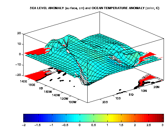
So how does the atmosphere "know" about El Niño? It is useful to imagine a chain of atmospheric processes, with each link in this chain carrying information from the local vicinity of the El Niño sea surface temperature (SST) anomalies throughout the global climate system. The first link is the tropical response of rain-producing cumulonimbus; critical because deep convection is the principal agent for exchanging heat from Earth's surface and thereby communicating El Niño's presence to the free atmosphere. Wet tropical climates tend to coincide with the warm pool SST area in the western Pacific, and the continental monsoons. During El Niño, rainfall increases over a distance of several thousand kilometers along the equator from the central to the eastern Pacific in response to the warming of the underlying SSTs, as shown in the next figure (red: wet). Reduced rainfall occurs on the periphery of this wet zone, and even the continental monsoons are not spared ENSO's influence. The opposite effect tends to be experienced during La Niiña, although the west-east scale of rainfall anomalies over the equatorial Pacific is somewhat reduced compared to warm events.
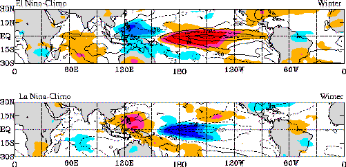
The second link in the chain is the horizontal communication of El Niño's presence, and this involves the sensitivity of the atmosphere's circulation to shifts in organized cumulonimbus convection. Atmospheric wave motions are excited that are necessary to adjust the climatological flow to the new tropical energy sources; not unlike the waves generated by a pebble dropped into a pond, although for ENSO the spatial scales of forcing are much larger and the atmosphere is steadily forced. As one can see from the pattern of rainfall anomalies in the adjacent figure, the major convection anomalies themselves are confined to within a few degrees of the equator during winter. However, associated with them is a circulation of mass and energy in the atmosphere that extends several thousand kilometers poleward into the subtropics. A deflecting force, due to the earth's rotation, acts upon this outflow along its poleward course, thereby initiating a wave-like pattern in the perturbed flow. In addition, the climatological circulation in higher latitudes acts to channel the course of this poleward flowing energy. This flow is directed from west to east, has concentrated westerlies along the jet streams east of Asia and North America, and is characterized by stationary waves of alternating low and high pressure.
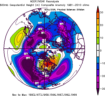
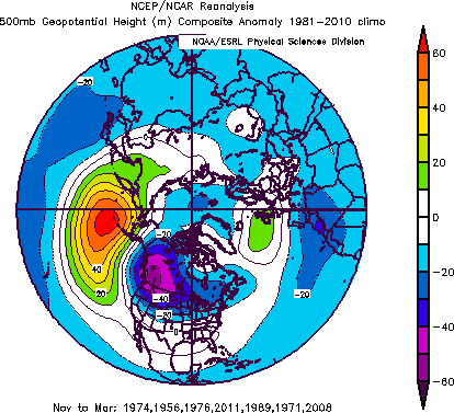
Through interactions with this background flow, the resulting atmospheric response to El Niño also consists of a wave train pattern having alternating low and high pressure, as shown by contours of the flow anomalies in the first and third panels. In the northern hemisphere, the wind circulates parallel to these contours, with low pressure to the left of the motion's direction The arrows give some sense of the anomalous wind direction at the jet stream level. The wave paths follow "great circle" routes that arch poleward into the higher reaches of the Pacific-North American region, and then curve equatorward into the subtropical western Atlantic. A similar wave pattern in the atmosphere exists in the Southern Hemisphere with an attendant influence on the climate of South America.
The anomalous wave patterns displayed in the figure are referred to as the atmospheric "teleconnections" linking equatorial and high latitudes during ENSO. These are based on a historical composite of how the atmosphere has behaved during the ten strongest El Niño and La Nina events of the 1950-96 period. Several features of note are the stronger Pacific jet during El Niño and an eastward shift of the stationary wave pattern over the Pacific-North American region during El Niño. These upper tropospheric changes alter the course of storms (cyclone and anticyclones) that control the daily weather fluctuations in the higher latitudes. Changes in statistical properties of storms (for example, their frequency, strength, or origin and tracks) account for the bulk of ENSO's signal in precipitation and surface temperature in the higher latitudes. Such "storm track" feedbacks constitute a third essential link along the chain that is initiated by the equatorial Pacific SST anomalies.
Each El Niño event has a unique signature in its SST lifecycle, and the question of the atmosphere's sensitivity to such inter-El Niño variations is matter of intense research focus having important implications for seasonal climate predictions.