Suggestions for using PSL Interactice Webpsages to investigate El Ni˝o:
PSL maintains an extenive collection of interactive webtools that allow users to not just plot data but to investigate climate relationships. The following is an example of how these pages can be used to teach the concept of El Nino A complete searchable list of interactive webpages is available. Background information on El Ni˝o can be found at the PSL El Ni˝o Web Page.The suggestions are somewhat specific. Please feel free to experiment with changing some of the suggested parameters (for example variable or season). It is suggested that you open another browser window to follow the examples suggested below. There is a link directly to the output plot to check results.
El Ni˝o and the Southern Oscillation
In the 1930's, Gilbert Walker documented the out-of-phase relationship between sea level pressures(SLP's) in the western tropical Pacific and the southeastern tropical Pacific. He called this pattern the "Southern Oscillation" (SO) (see History of the Southern Osciallation Index for a more detailed history). This sea-saw pattern of pressures was associated with different rainfall and windfield patterns over the Pacific and over other parts of the globe. The out-of-phase relationship of the SO can be seen by plotting the time series of sea level pressure over the different parts of the Pacific:
 Time Series SLP plot Eastern Pacific
[plot parameters]
Time Series SLP plot Eastern Pacific
[plot parameters]
 Time Series SLP plot Western Pacific
[plot parameters]
Time Series SLP plot Western Pacific
[plot parameters]
The large scale SLP pattern can be seen by looking at a map of the pressure anomalies for a year with a high value (Jan 1983).
SLP Jan 1983
[plot parameters]
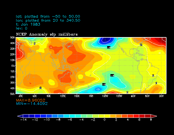
Produce a similar plot to the Jan 1983 plot but for the opposite phase of the SOI. How does that compare? Is the precipitation pattern similar for other seasons?
The rainfall patterns that are associated with this pattern can be seen by comparing an the average rainfall pattern with the pattern from Dec-Jeb 1983.
Precipitation over globe during Dec-Feb
[plot parameters]
 Precipitation anomalies Dec-Feb 1982-83over globe [plot parameters]
When the pressure is higher than normal over the western tropical Pacific, the convection that is normally there shifts eastward and as a result there is less rainfall than normal there but an increased amount east of the dateline.(optional)Produce a precipitation plot for the opposite phase of the SOI. How does that compare? Is the precipitation pattern similar for other seasons?The connection between this see-saw or "Southern Oscillation" pattern and a similar reversal of typical Sea Surface Temperatures wasn't noticed until the 1960's. El Ni˝o refers to the quasi-periodic increase in ocean temperatures in the eastern tropical Pacific and the resulting circulation changes. El Ni˝o is traditionally defined by the ocean temperatures in the eastern Pacific.
SST plot
[plot parameters]
 SST anomaly plot 1982-83
[plot parameters]
SST anomaly plot 1982-83
[plot parameters]
Note the much warmer than usual temperatures over the eastern tropical Pacific. What kind of circulation would you expect to be associated with these temperatures? How would you expect the difference in temperatures to affect rainfall (primarily convection)? How does this SST pattern compare to other El Ni˝o years (hint, look at a time series of SST averaged over the eastern tropical Pacific)? How does it compare to La Nina years (colder than normal in the eastern Pacific)? How does it compare to the SLP time sereis?
Local wind field plot Dec-Feb
[plot parameters]
 Local wind field anomaly plot Dec 1982-Feb 1983
[plot parameters]
Local wind field anomaly plot Dec 1982-Feb 1983
[plot parameters]
Note that the winds go to westerly over the equatorial region during an El Ni˝o. Is that what you would expect? How would the change in wind speed affect temperature near the surface? What about change in direction?