Meteorological March Madness 2012
Draft - Last Update: 11 December 2012
Disclaimer: This draft is an evolving research assessment and not a final report. The analyses presented have not yet been peer reviewed and do not represent official positions of ESRL, NOAA, or DOC. A more technical and detailed analysis of the heat wave has been submitted to the Bulletin of the American Meteorological Society for peer review. Comments are welcome. For more information, contact Dr. Martin Hoerling (martin.hoerling@noaa.gov)
The Meteorology
The March 2012 heatwave cannot be understood without considering the prevailing meteorological conditions. In this section, the global context of the U.S. heatwave is discussed, the various aspects of the wind and pressure patterns from the Earth's surface to the free atmosphere are described, and their relation to the surface heatwave expression is assessed.
1. What were the meteorological conditions associated with the heatwave?
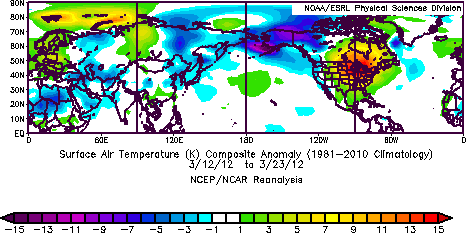
Figure 1: Map of Northern Hemisphere temperature anomalies averaged over the period. Anomalies are calculated relative to the period 1981-2010.
[Data Source: NCEP/NCAR Reanalysis]
|
It is first useful to place the heatwave into a Northern Hemisphere context (Fig. 1). The heatwave was clearly regional in scope and was not part of a pervasive hemisphere-wide warm regime. Rather, widespread cold conditions at the same time occurred over the western U.S., western Canada, Alaska, eastern Asia, and southeast Europe. In a similar context, it is useful to recall that the prior month of February 2012 which was generally very warm over the U.S., was very cold over Europe, and global land temperatures ranked 37th warmest in over a century, representing the coolest February since 1994 (http://www.ncdc.noaa.gov/sotc/global/2012/2).
Over the Eastern United States, select time series of daily temperatures (Fig. 2) reveal the timing and magnitude of the maximum warming. A peak warming in the upper Midwest spans roughly a 12-day period from 12 - 23 March.

|

|
|

|
|
|
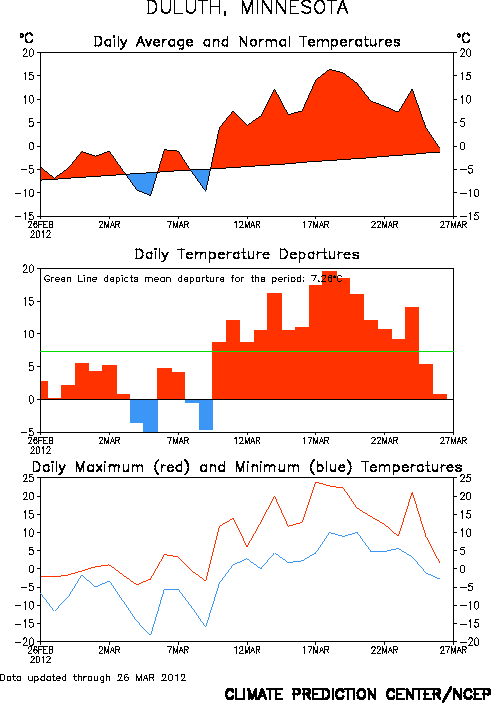
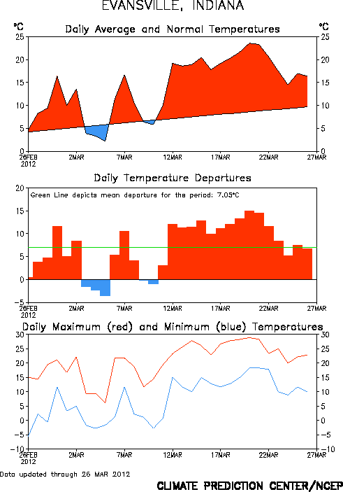
Figure 2: Time series plots of daily temperatures for selected stations in the upper MidWest. [Source: NOAA/CPC]
|
||||
While the time series alone do not divulge the underlying causes for the heatwave, they do nonetheless offer clues --- the step-like onset of the heatwave reveals the presence of strong synoptic forcing. One notes in particular the abrupt onset of the extreme warmth at Minneapolis, Duluth, and International Falls on 10 March. This step-like warming with +10�C departures occurred in the wake of several prior cold days. Further east, Evansville, Indiana and Chicago also experienced a sudden warm spike, but not until the 12th of March.
The very warm air first pushed northward west of the Great Lakes region, and subsequently spread eastward. This synoptic view is consistent with structural aspects of the atmospheric circulation, shown in the Physical Processes section, that reveal intense poleward air mass movement propelled by an unusually intense low level southerly jet that stretched from Louisiana to western Wisconsin. Once this warm surge inundated the area, a remarkably prolonged period of record setting temperatures ensued. These time series thus identify a core period of the maximum heatwave intensity that spanned roughly 12 March thru 23 March, a period for which we will perform various time averaged analyses.

|
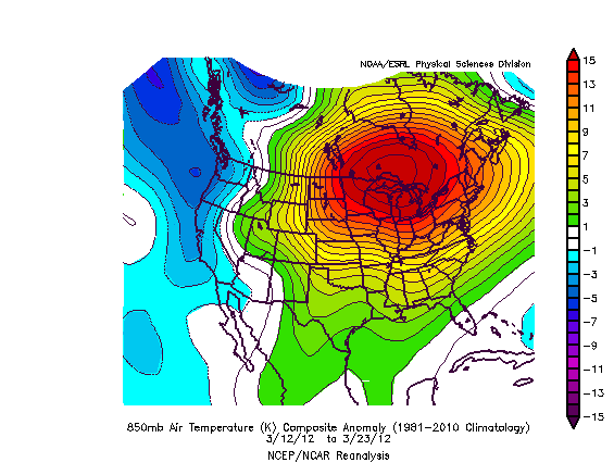
Figure 3: Maps of US surface (top) and 850 hPa (bottom) temperature anomalies averaged over the period March 12-23, 2012. Anomalies are calculated relative to the period 1981-2010.
[Data Source: NCEP/NCAR Reanalysis]
|
An outstanding characteristic of the heatwave was its penetration through a tropospheric layer, a feature which is telling of the principal physical processes responsible for the surface warming. The time averaged surface and 850mb temperature anomalies were virtually identical in pattern and magnitude (Fig. 3). Maxima of +15�C extend over the Great Lakes region, but warm conditions covered all of the US east of the Rocky Mountains during this 12-day period. It is this vertical structure of the temperature anomalies that allows one to reject the conjecture for a strong in situ surface driving of the heatwave that may have resulted from either soil moisture or snow cover/albedo feedbacks. More on this shortly. Suffice it to say here that the meteorological setting of this heatwave was strongly dynamic.

|
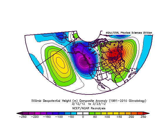
Figure 4: 500 hPa geopotential height composite mean (top) and
anomaly (bottom).
[Data Source: NCEP/NCAR Reanalysis]
|
The dynamical attributes involved a wave train pattern of upper tropospheric anomalies extending from eastern North America westward toward the tropical central Pacific. The pattern, shown for the 500 hPa surface in Fig. 4 (bottom) reveals a Rossby wave train apparently emanating from the tropical Pacific that is characteristic of late wintertime teleconnections over the Pacific and North American region. This pattern was not a "block" (see Fig. 4, top) in a classically defined sense, however, its persistence served to organize the weather systems and low level circulation regimes through which the U.S. March heatwave underwent its primary development. In particular, evidence will be presented in the next section that a strong low level southerly jet was initiated and sustained by the greatly enhanced west-east pressure gradient between the abnormal low pressure over the western U.S. and abnormally high pressure over the Northeast U.S. This feature was probably the single most critical factor responsible for the extreme magnitude of the heatwave.
We will also demonstrate, using seasonal climate forecast models, that the circulation pattern and the associated heatwave was remarkably predictable at long lead times, from initial atmospheric conditions at about 1 February 2012. This fact also gives important further clues on the leading processes responsible for the heatwave. Importantly, the meteorological conditions associated with the heatwave had an appreciable, and perhaps unusual, long-lead predictive element.