NOAA NASA Joint Archive (NNJA) of Observations for Earth System Reanalysis
About
A team of scientists from NOAA and NASA are collaborating on a curated joint observation archive containing Earth system data from 1979 to present. The goal is to foster collaboration across organizations and develop the ability for direct comparison of Earth System reanalysis results.
Providing a singular dataset for observation input use will allow reanalyses to be compared on their unique development qualities by removing the variation from using different observations.
About the dataset
The archive is hosted in an Amazon Web Services (AWS) S3 bucket with ocean, ice, land and atmosphere observations in formats including bufr, ioda, and netcdf. Some data is reprocessed as appropriate. The dataset also includes specification of observational errors and a black/white list for historic observations.
Future state
Future goals include extending the observations from 1979 to near real-time extension (with a 72-hour delay), expansion of observation types, conversion of bufr into ioda, a user-friendly API for easy incorporation into reanalyses products, and ongoing development of improved diagnostic tools for comparing experimental results.
We anticipate that the open dataset will be of value to the wider Earth System community, including future applications outside of the original goal of reanalysis production.
The end result of the project will be a publicly accessible dataset for observations and tools for consistent comparisons between reanalysis products.
How to cite
Example: NOAA NASA Joint Archive (NNJA) was accessed on [DATE] from https://psl.noaa.gov/data/nnja_obs/
Please go to the How to Cite tab for license and additional information.
Inventories
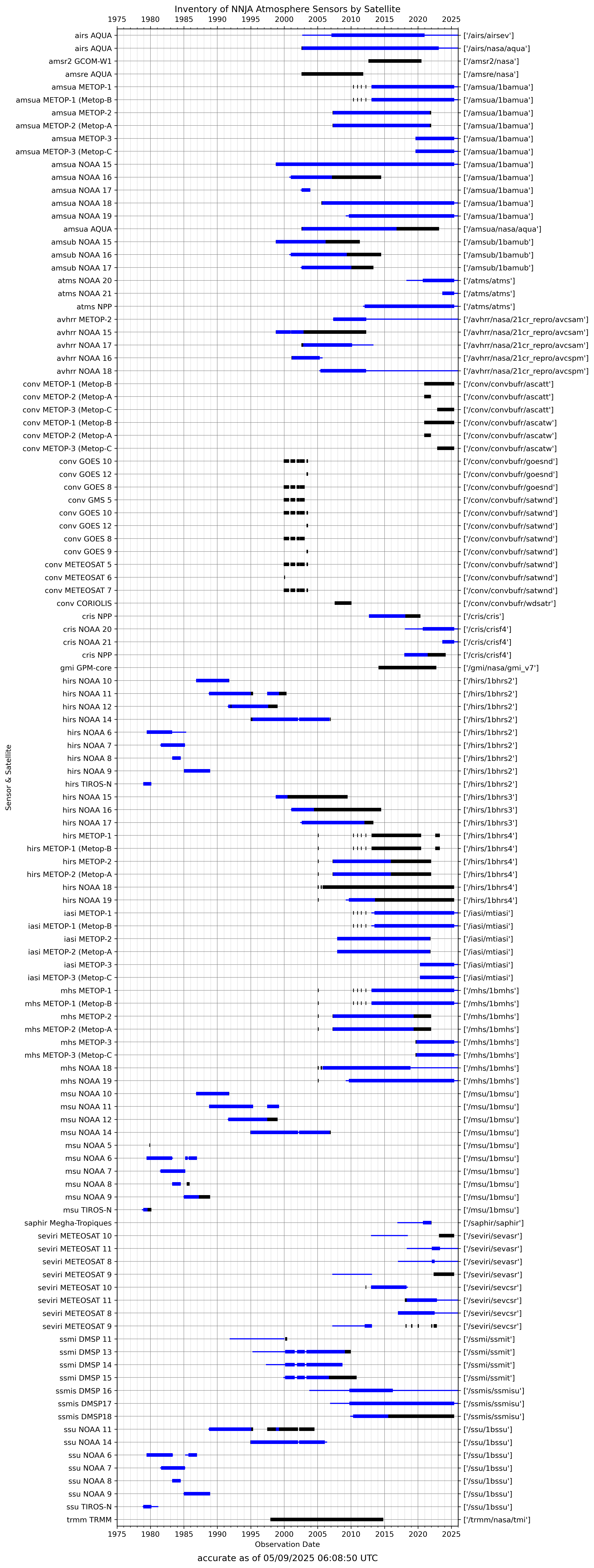
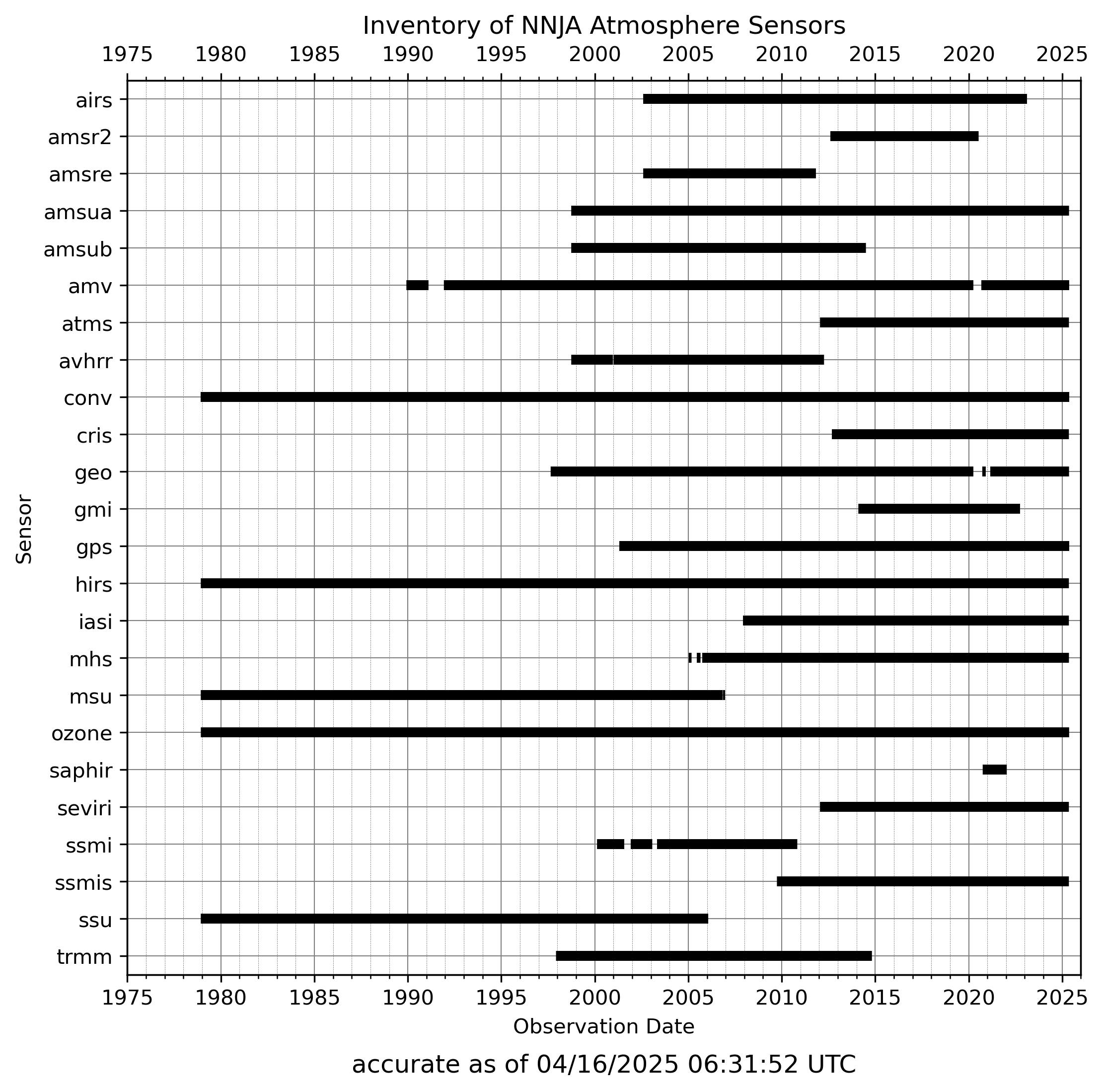
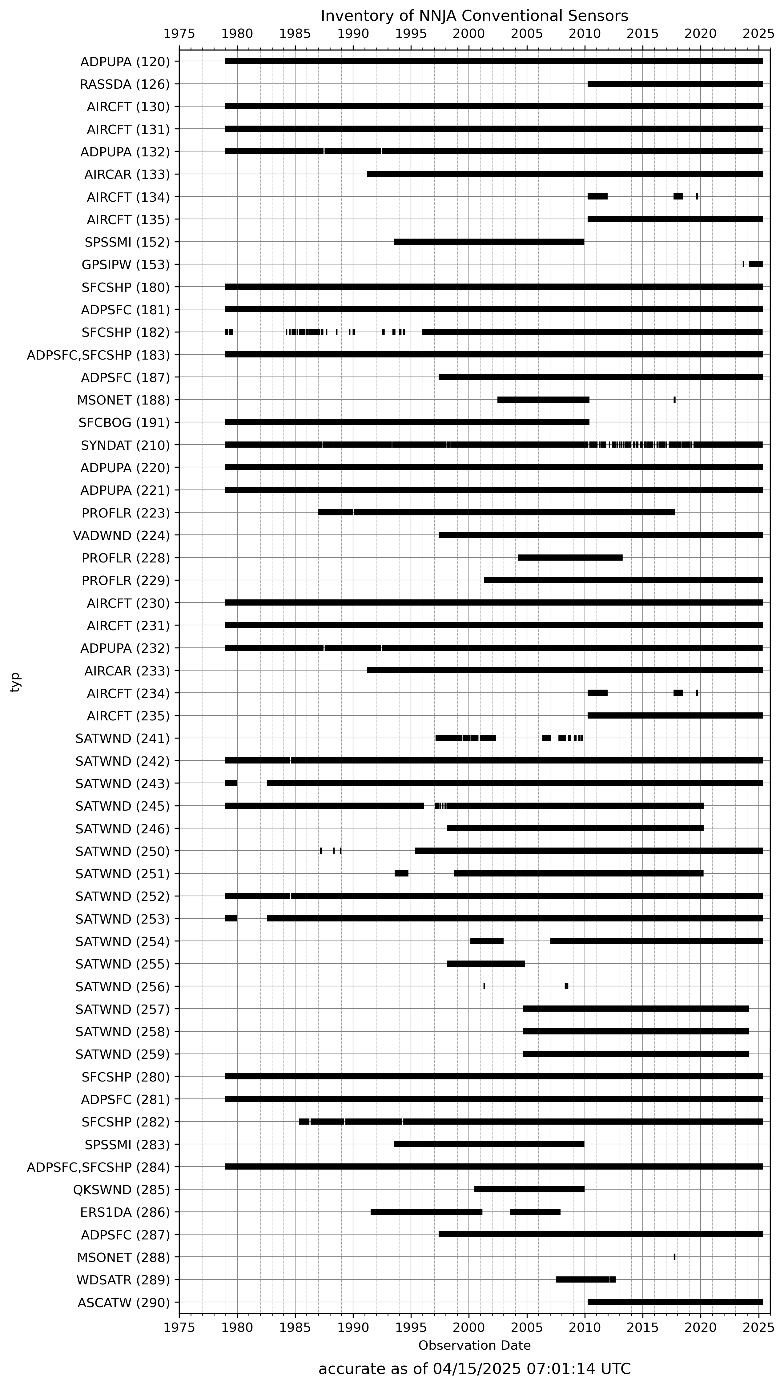
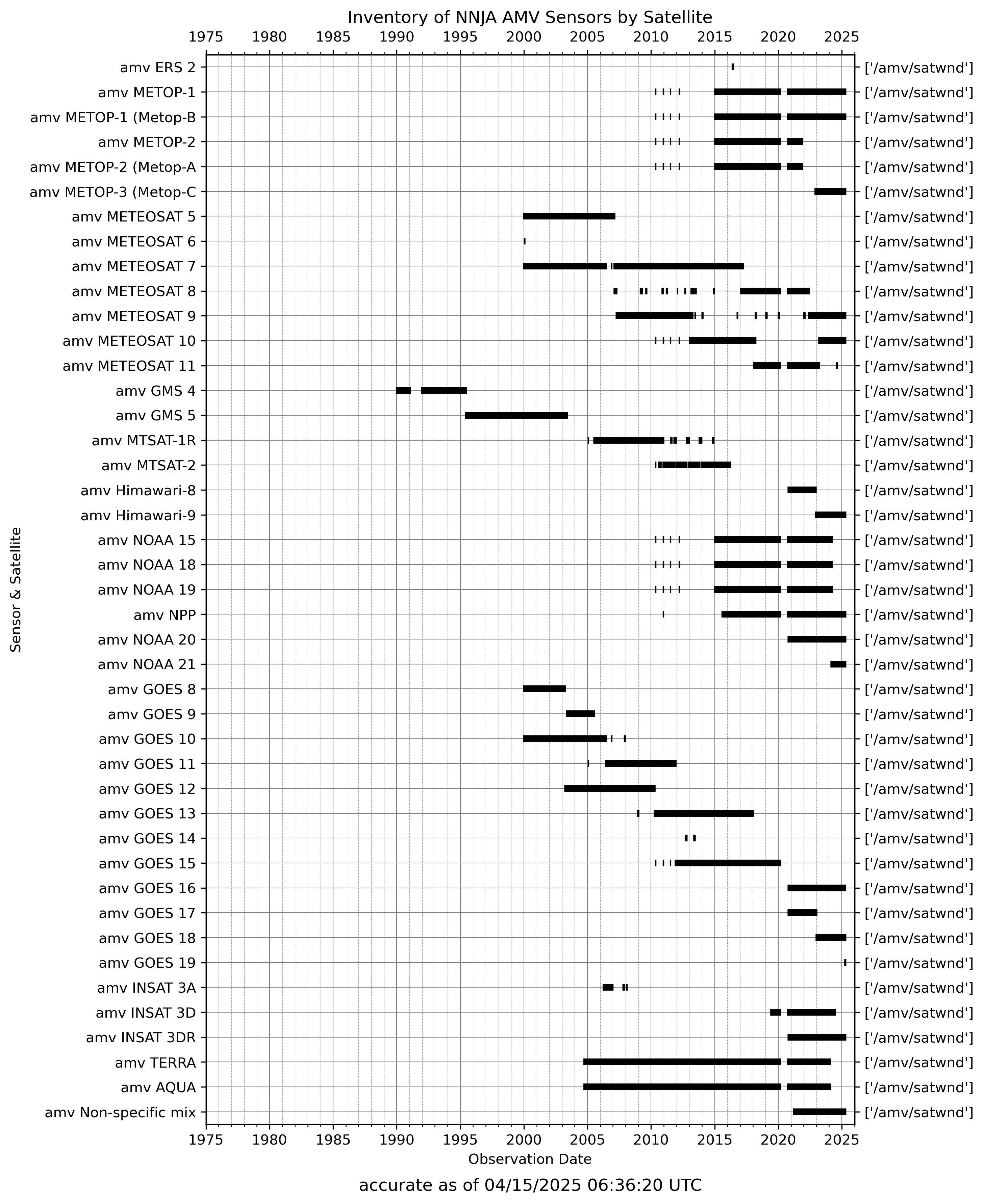
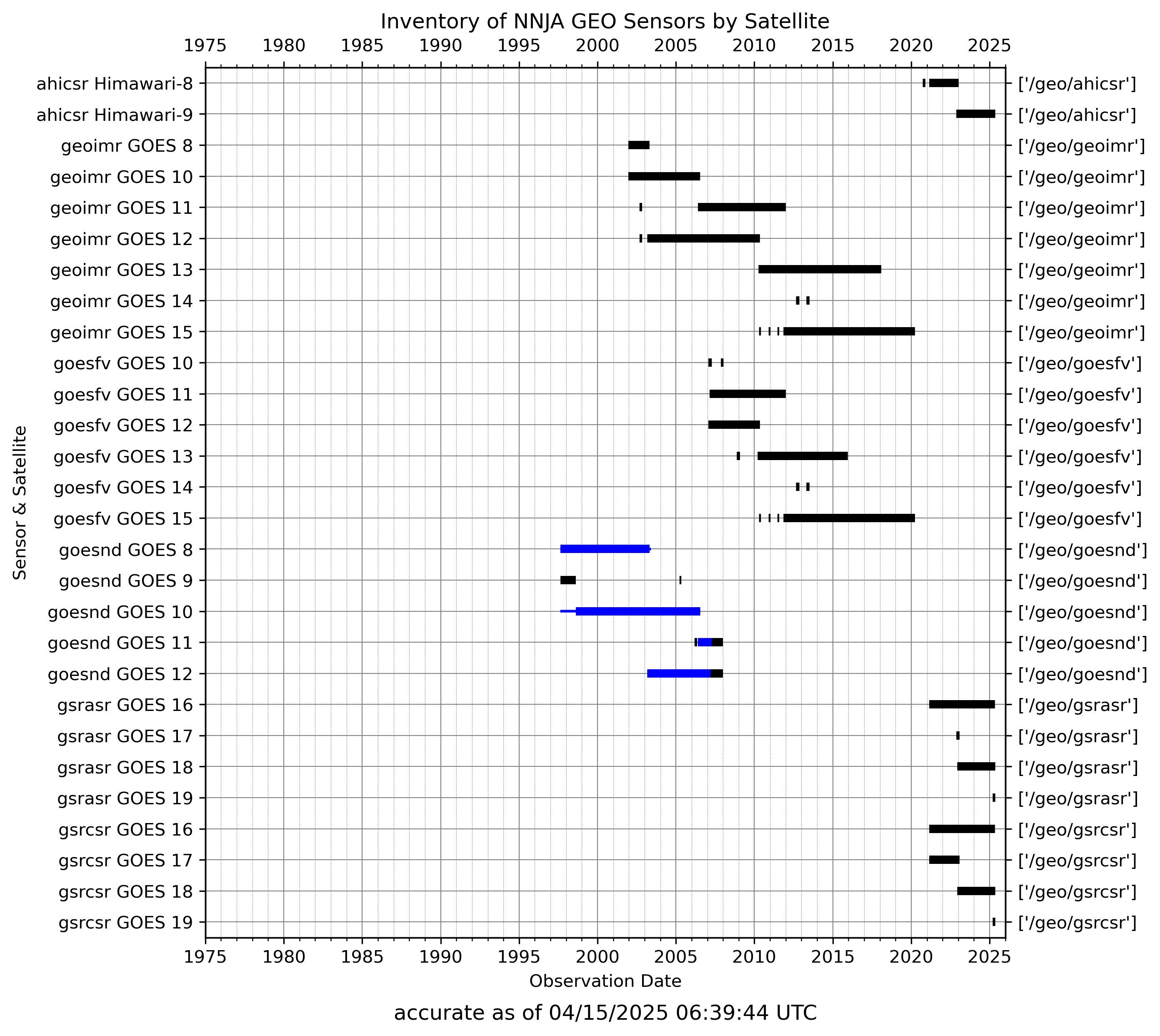
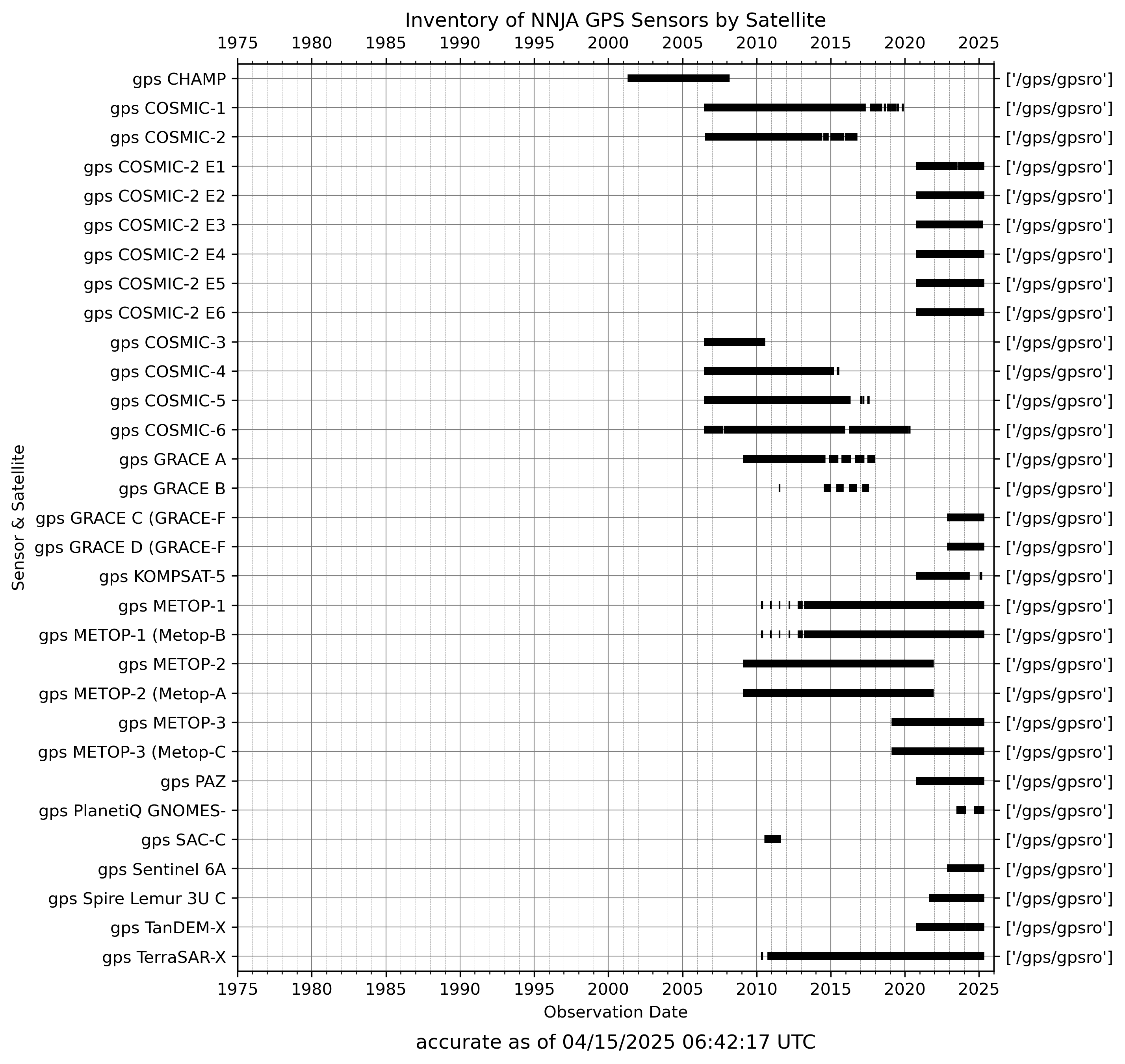
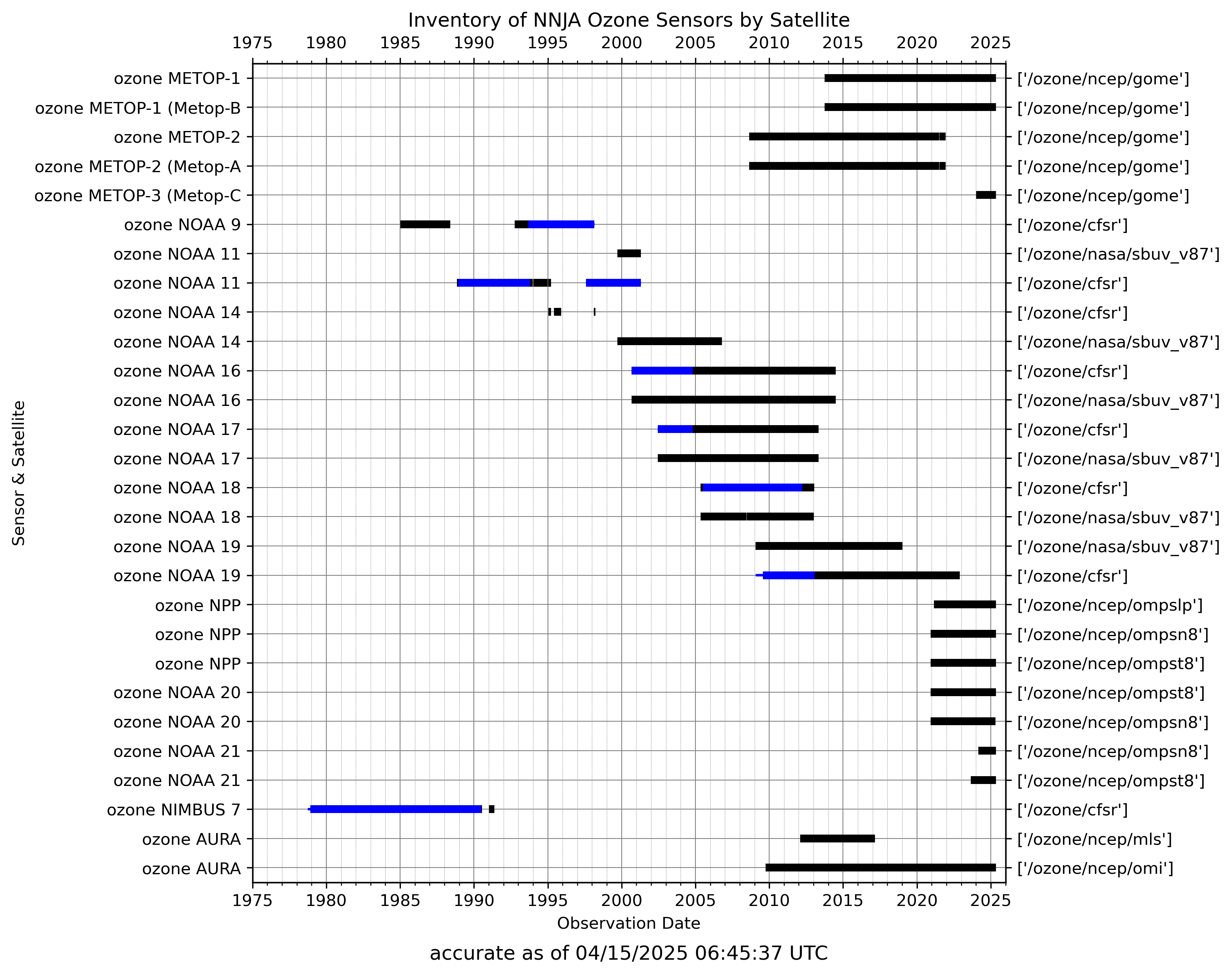
The following inventory plots are updated daily.
Notes
- Ocean and Ice inventory work is ongoing and not currently reflected in our graphics but can be found in the archive.
- For data which is currently being assimilated in the ongoing NOAA reanalysis products, the inventory lines will appear in blue in accordance with the satellite black/white lists available on our data page.
- If a line is thick, black or blue, it shows that we have that data in our archive. If a line is thin and blue, it means our system will assimilate the data once it is added to the archive but is not currently located in the archive.
Data Access
Links on this page will open in a new browser tab.
- S3 Bucket
- General bucket structure: noaa-reanalyses-pds/observations/reanalysis/{sensor}/{source(s)}/YYYY/MM/{file format}/{data files}
- Github Black/White List
- The information from the ‘satinfo’ files is reflected in our satellite based graphics on the Inventory tab.
Data Sources
Select a button to see list of variables for that category linked to more information on their respective source. All links external
Atmosphere- adt
- airs
- amsua
- amsub
- amv
- atms
- avhrr
- AVHRR
- AVHRR/2
- AVHRR/3
- conv
- cris
- geo
- IMAGER (GOES 8-11)
- IMAGER (GOES12-15)
- SOUNDER
- gmi
- gps
- ROM SAF Metop
- ROM SAF COSMIC
- ROM SAF GRACE
- ROM SAF CHAMP
- GRAS
- IGOR (COSMIC)
- BlackJack (GRACE)
- BlackJack (CHAMP)
- hirs
- HIRS/2
- HIRS/3
- HIRS/4
- iasi
- mhs
- msu
- ozone
- GOME
- GOME-2
- OMPS-limb
- OMPS-nadir
- MLS
- MLS (EOS-Aura)
- OMI
- SBUV
- SBUV/2
- MLS NRT
- OMI NRT
- OMPS NRT
- saphir
- seviri
- ssu
- trmm
- Concentration
- Free board
How to cite
NOAA NASA Joint Archive (NNJA) of Observations for Earth System Reanalysis data is distributed under the Creative Commons Attribution 4.0 International (CC BY 4.0) license.
To provide appropriate attribution under this license, please cite the link to this PSL website.
For example: NOAA NASA Joint Archive (NNJA) was accessed on [DATE] from https://psl.noaa.gov/data/nnja_obs/
