Remote Sensing Using GPS
Knowledge of sea state is necessary for accurate marine weather forecasts for ensuring the safety of fleets and to manage marine traffic. Measurements of sea state, together with heat and moisture fluxes over the globe, are required for climate-change and weather-prediction models. Soil moisture affects the development of weather patterns and the production of precipitation. In addition to weather and climate, soil moisture controls floods, soil erosion, and slope failure. Also, soil moisture data are critical for agriculture, reservoir management, geotechnical engineering, and water quality. Melting Arctic sea ice, declining sea ice extent and thickness, major changes in Arctic and North Atlantic air and ocean circulation have great impact on the Earth's climate.
Methods
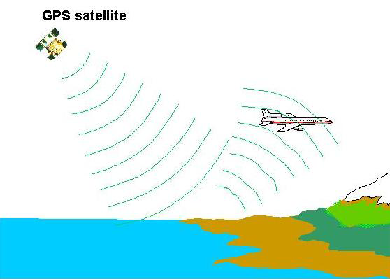
To monitor, map, and study sea state, soil moisture, and Arctic ice, very sensitive imaging radiometers and radars have been developed. Radiometers receive weak electromagnetic radiation which is naturally emitted by the Earth's surface, and radars send their own radio pulses toward the surface. Recently, researchers have proposed an inexpensive new remote sensing tool that could complement radiometers and radars. The system uses a Department of Defense Global Positioning System (GPS) navigation system. The GPS is comprised of a network of 28 satellites orbiting 20,000 km above the Earth, along with a network of ground tracking stations. By measuring the time required for signals to travel from the satellites to the receivers, the positions of the receivers can be precisely determined.
The GPS signal can also arrive to the receiver from nearby reflecting surfaces. This phenomenon is known as multipath. Normally, multipath signals interfere with the signals received directly from the satellites, reducing positioning accuracy. Researchers from PSL, however, are using a concept that employs GPS multipath signals reflected off the ocean or land as a source of valuable new information about sea state, soil moisture, snowpack, and sea ice. Fortuitously, land surface reflections of a radio wavelength of ~ 20 cm emitted by GPS transmitters are very sensitive to these environmental parameters. This GPS application is exploiting the GPS signal as a signal of opportunity.
Activities and Outcomes
PSL researchers in collaboration with colleagues from the Jet Propulsion Laboratory at the California Institute of Technology, NASA Langley Research Center, University of Colorado at Boulder, the Applied Physics Laboratory at Johns Hopkins University, and Purdue University, have shown that the weak reflected GPS signals can be detected by airborne instruments and used to map ocean surface topography, measure ocean waves and surface winds, soil moisture, and sea ice.
To further this technique, researchers are now studying the feasibility of making such measurements for NOAA operational needs. From 2002 to 2005 measurements of soil moisture under bare-soil conditions were made from a 300-m meteorological tower using bistatic GPS reflection as a part of a collaborative effort between NOAA, the University of Colorado at Boulder and the First RF Corporation. In that experiment, the data were obtained from simultaneous use of several receiving antennas with various gain and polarization sensitivities. Subsequently, the reflection measurements have also been accompanied by L-band radiometric measurements of soil moisture. In September 2006, we installed their GPS bistatic radar altimeter on a NOAA P-3 aircraft, seeking to assess the possibility of obtaining storm surge measurements. While there were no landfalling hurricanes in 200 6, altimetric data show that the storm surge can be measured to an accuracy of ~ 1 m over 1 s of the flight time. The results of these studies will be invaluable to NOAA's development of operational GPS sensors.