2.1 Understanding and predicting seasonal tropical SST variations
CDC scientists have pioneered the development of Linear Inverse Modeling (LIM) as a diagnostic and forecasting tool. LIM is a method of extracting the dynamical parameters of a system from data. The assumption is made that the dynamics can be modeled as a stable linear multivariate process driven by geographically coherent white noise. The estimated dynamical parameters can then be used to make forecasts of the system. Real-time seasonal LIM forecasts of tropical Indo-Pacific SST anomalies are published monthly in the Climate Diagnostics Bulletin and quarterly in the Experimental Long-Lead Forecast Bulletin (ELLFB). They are also available through CDC's website at http://psl.noaa.gov/~lem/IndoPacific.frcst.html.
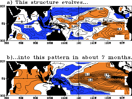
An important original result from our LIM diagnosis of Indo-Pacific SST variability was the identification, through a singular-vector analysis of the empirically-determined system propagator, of an optimal initial SST pattern for SST anomaly growth over 7 months in the basin. This structure evolves in 7 months into a pattern resembling a mature ENSO event (Fig. 2.1), and may therefore be viewed as a dynamically relevant precursor to ENSO.
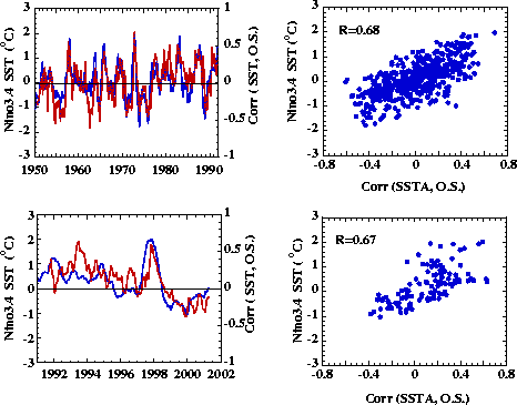
And indeed, as Fig. 2.2. shows, whenever an SST anomaly pattern projects appreciably on this structure, there is a good chance of obtaining large SST anomalies in the Niño 3.4 area 7 months later. Figure 2.2 also shows that the projection statistics are similar whether they are evaluated for a time period including the training period (COADS data: 1950-1990) or for independent data (NMC Real-time Surface Marine data: 1991-2001). Encouraged by this robust behavior, we now provide real-time monitoring of the projection of the SST anomaly field on this structure through our website at http://psl.noaa.gov/~lem/opt/optstr.html.
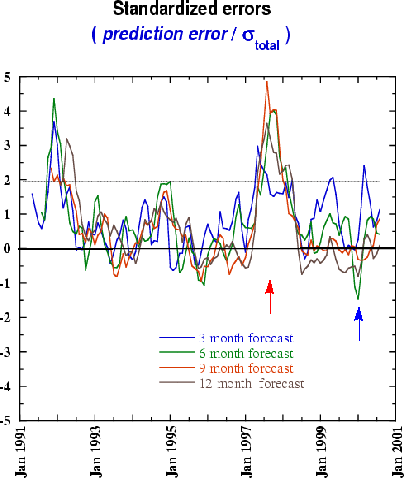
We have also recently published procedures for estimating improved confidence intervals on our SST forecasts. Until recently, the confidence intervals were those appropriate to our assumed stationary linear Markov process; that is, they showed the expected forecast error of a stable linear model driven by stationary white noise. The improved error bars also include estimated contributions from our neglect of the seasonal variation of the stochastic forcing, from estimating the model's parameters in a training period of finite length, and from initial condition errors.
The actual forecast error normalized by the rms of the total expected error estimated in this manner (Fig. 2.3) shows how much better the forecast skill is during La Niña than El Niño. This is consistent with our conclusion, stated in several papers, that nonlinear dynamics become important during the warmest phase of warm events. We have continued to investigate the failure of LIM during such periods. Although the lack of skill is mostly due to the greater importance of nonlinearity, an interesting recent finding was that LIM would nevertheless have been useful during late 1994-early 1995 had it been applied to weekly instead of seasonal SSTs. Evidence has also been found that unpredictable stochastic forcing accounted for a large portion of the observed warming during the strong 1997-1998 event.
CDC also provides LIM forecasts of the tropical north Atlantic and Caribbean SSTs in the ELLFB. Again, these forecasts are available through our website at http://psl.noaa.gov/~lem/Atlantic.forecast.html. We have shown that forecast skill in these Atlantic regions is related to the skill of predicting El Niño. We have also used LIM to diagnose the dynamical nature of tropical Atlantic SST variability, and published evidence that the familiar "dipole" SST anomaly pattern is a dynamically realizable structure (as opposed to merely the dominant EOF of regional SST variability), but whose development is often interrupted by ENSO influences from the east Pacific.
Our original claim that the basic dynamics of ENSO are stable, linear and stochastically forced has been independently confirmed by others and is gradually forcing a paradigm shift in this field. We have continued investigating the dynamical nature of ENSO, especially in collaboration with scientists at Texas A&M University. A recently published study showed that an intermediate coupled ENSO-prediction model of the Cane-Zebiak type, tuned to be in a stable stochastically forced regime, generated more realistic SST variability than did the same model tuned to give self-sustained oscillations.